Condon elevation
Condon (Oregon, Gilliam County), United States elevation is 861 meters and Condon elevation in feet is 2825 ft above sea level [src 1]. Condon is a seat of a second-order administrative division (feature code) with elevation that is 582 meters (1909 ft) bigger than average city elevation in United States.
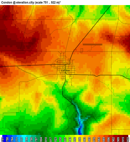
Below is the Elevation map of Condon, which displays elevation range with different colors. Scale of the first map is from 751 to 922 m (2464 to 3025 ft) with average elevation of 863 meters (=2831 ft) [note 1]
These maps also provides idea of topography and contour of this city, they are displayed at different zoom levels. More info about maps, scale and edge coordinates you can find below images.
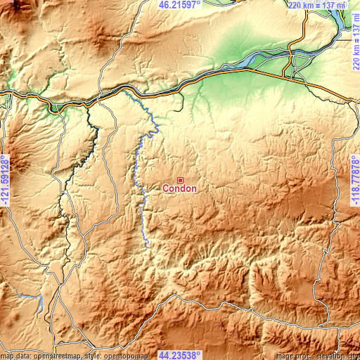
| \ | Map #1 | Topo.Map |
| Scale [m] | 751..922 m | × |
| Scale [ft] | 2464..3025 ft | × |
| Average | 863 m = 2831 ft | × |
| Width | 6.88 km = 4.3 mi | 220.2 km = 136.8 mi |
| Height | 6.88 km = 4.3 mi | 220.2 km = 136.8 mi |
| ↑Max Latitude | 45.265238° | 46.21597° |
| Latitude at center | 45.2343° | 45.2343° |
| ↓Min Latitude | 45.203345° | 44.23538° |
| ← Min Longitude | -120.228975° | -121.59128° |
| Longitude center | -120.18503° | -120.18503° |
| →Max Longitude | -120.141085° | -118.77878° |
Nearby cities:
Cities around Condon sort by population:
• Hermiston elevation 140 m
97 km,  45°
45°
• The Dalles 81 m
87.3 km,  297°
297°
• Goldendale 497 m
81.9 km,  322°
322°
• Boardman 94 m
77.2 km,  29°
29°
• Warm Springs 466 m
99.8 km,  238°
238°
• Stanfield 181 m
96.8 km, 51°
• Chenoweth 131 m
93.4 km, 297°
• Irrigon 92 m
91.2 km,  36°
36°
• Heppner 656 m
50.8 km,  74°
74°
• Dallesport 65 m
88.5 km, 298°
• Fossil 806 m
26.4 km,  185°
185°
• Moro 553 m
50.9 km, 303°
Multilingual:
 En español:
Condon elevación 861 m.
 En France:
Condon élévation 861 m.


Sources and notes:
- [note 1] Map square and city borders are not equal. Map elevation data is calculated only from area inside that square.
- [src 1] Elevation data from geonames database provided with same terms of usage.
- [src 2] The elevation map of Condon is generated using elevation data from NASA's 3 arcsec (90m) resolution SRTM data.
- [src 3] Base (background) map © OpenStreetMap contributors tiles are generated by Geofabrik and OpenTopoMap.
Copyright & License:
This Condon Elevation Map is licensed under CC BY-SA. You may reuse any part from this page, if you give a proper credit by linking to this URL:
 More info on terms of use page.