Pendleton elevation
Pendleton (Oregon, Umatilla County), United States elevation is 327 meters and Pendleton elevation in feet is 1073 ft above sea level [src 1]. Pendleton is a seat of a second-order administrative division (feature code) with elevation that is 48 meters (157 ft) bigger than average city elevation in United States.
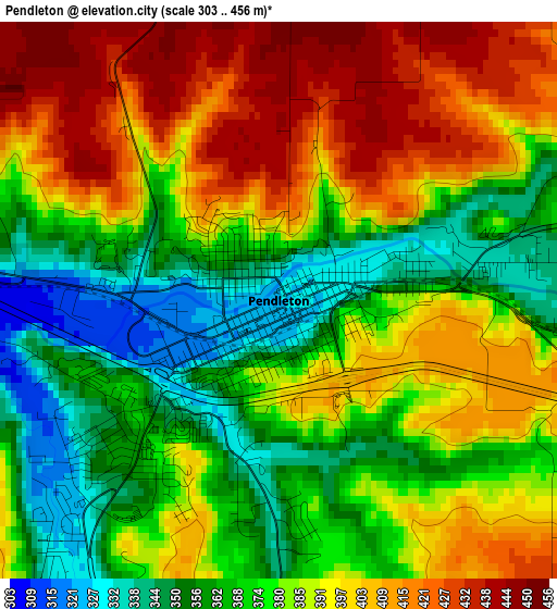
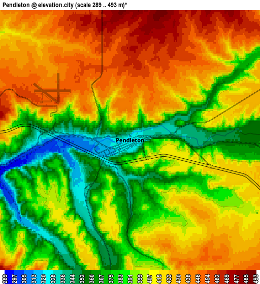
Below is the Elevation map of Pendleton, which displays elevation range with different colors. Scale of the first map is from 303 to 456 m (994 to 1496 ft) with average elevation of 383.9 meters (=1260 ft) [note 1]
These maps also provides idea of topography and contour of this city, they are displayed at different zoom levels. More info about maps, scale and edge coordinates you can find below images.
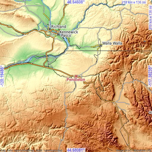
| \ | Map #1 | Map #2 | Topo.Map |
| Scale [m] | 303..456 m | 289..493 m | × |
| Scale [ft] | 994..1496 ft | 948..1617 ft | × |
| Average | 383.9 m = 1260 ft | 405.1 m = 1329 ft | × |
| Width | 6.83 km = 4.2 mi | 13.66 km = 8.5 mi | 218.5 km = 135.8 mi |
| Height | 6.83 km = 4.2 mi | 13.66 km = 8.5 mi | 218.5 km = 135.8 mi |
| ↑Max Latitude | 45.702769° | 45.733451° | 46.64608° |
| Latitude at center | 45.67207° | 45.67207° | 45.67207° |
| ↓Min Latitude | 45.641354° | 45.610621° | 44.68081° |
| ← Min Longitude | -118.832545° | -118.876491° | -120.19485° |
| Longitude center | -118.7886° | -118.7886° | -118.7886° |
| →Max Longitude | -118.744655° | -118.700709° | -117.38235° |
Nearby cities:
Cities around Pendleton sort by population:
• Walla Walla elevation 287 m
55.6 km,  38°
38°
• Hermiston 140 m
43.1 km,  295°
295°
• College Place 243 m
52.2 km, 36°
• Milton-Freewater 318 m
42.5 km,  47°
47°
• Umatilla 98 m
50.9 km, 302°
• Finley 106 m
56.8 km,  340°
340°
• Stanfield 181 m
35.4 km,  289°
289°
• Walla Walla East 310 m
56.5 km, 41°
• Pilot Rock 521 m
21.2 km,  188°
188°
• Garrett 233 m
51.7 km, 35°
• Athena 524 m
27.9 km,  56°
56°
• Mission 369 m
8.2 km,  91°
91°
Multilingual:
 En español:
Pendleton elevación 327 m.
 En France:
Pendleton élévation 327 m.
 Auf Deutsch:
Pendleton höhe über dem Meeresspiegel ist 327 m.

Sources and notes:
- [note 1] Map square and city borders are not equal. Map elevation data is calculated only from area inside that square.
- [src 1] Elevation data from geonames database provided with same terms of usage.
- [src 2] The elevation map of Pendleton is generated using elevation data from NASA's 3 arcsec (90m) resolution SRTM data.
- [src 3] Base (background) map © OpenStreetMap contributors tiles are generated by Geofabrik and OpenTopoMap.
Copyright & License:
This Pendleton Elevation Map is licensed under CC BY-SA. You may reuse any part from this page, if you give a proper credit by linking to this URL:
 More info on terms of use page.