Walla Walla East elevation
Walla Walla East (Washington, Walla Walla County), United States elevation is 310 meters and Walla Walla East elevation in feet is 1017 ft above sea level [src 1]. Walla Walla East is a populated place (feature code) with elevation that is 31 meters (102 ft) bigger than average city elevation in United States.
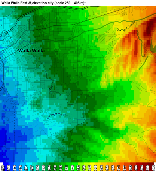
Below is the Elevation map of Walla Walla East, which displays elevation range with different colors. Scale of the first map is from 259 to 405 m (850 to 1329 ft) with average elevation of 316.6 meters (=1039 ft) [note 1]
These maps also provides idea of topography and contour of this city, they are displayed at different zoom levels. More info about maps, scale and edge coordinates you can find below images.
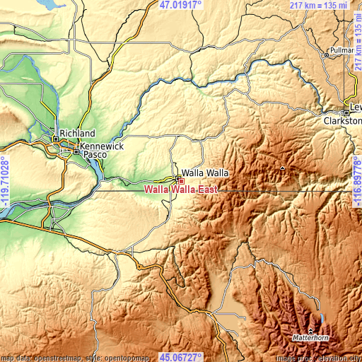
| \ | Map #1 | Topo.Map |
| Scale [m] | 259..405 m | × |
| Scale [ft] | 850..1329 ft | × |
| Average | 316.6 m = 1039 ft | × |
| Width | 6.78 km = 4.2 mi | 217 km = 134.8 mi |
| Height | 6.78 km = 4.2 mi | 217 km = 134.8 mi |
| ↑Max Latitude | 46.08233° | 47.01917° |
| Latitude at center | 46.05184° | 46.05184° |
| ↓Min Latitude | 46.021333° | 45.06727° |
| ← Min Longitude | -118.347975° | -119.71028° |
| Longitude center | -118.30403° | -118.30403° |
| →Max Longitude | -118.260085° | -116.89778° |
Nearby cities:
Cities around Walla Walla East sort by population:
• Walla Walla elevation 287 m
3.3 km,  295°
295°
• Pendleton 327 m
56.5 km,  221°
221°
• College Place 243 m
6.5 km,  267°
267°
• Milton-Freewater 318 m
14.7 km,  206°
206°
• Finley 106 m
57.4 km,  281°
281°
• Burbank 114 m
57.1 km,  286°
286°
• Dayton 505 m
39.6 km,  40°
40°
• Elgin 814 m
61.9 km,  151°
151°
• Garrett 233 m
7.6 km, 270°
• Waitsburg 382 m
26.9 km,  25°
25°
• Athena 524 m
30.3 km, 208°
• Mission 369 m
51.6 km, 214°
Multilingual:
 En español:
Walla Walla East elevación 310 m.
 En France:
Walla Walla East élévation 310 m.
 Auf Deutsch:
Walla Walla East höhe über dem Meeresspiegel ist 310 m.

Sources and notes:
- [note 1] Map square and city borders are not equal. Map elevation data is calculated only from area inside that square.
- [src 1] Elevation data from geonames database provided with same terms of usage.
- [src 2] The elevation map of Walla Walla East is generated using elevation data from NASA's 3 arcsec (90m) resolution SRTM data.
- [src 3] Base (background) map © OpenStreetMap contributors tiles are generated by Geofabrik and OpenTopoMap.
Copyright & License:
This Walla Walla East Elevation Map is licensed under CC BY-SA. You may reuse any part from this page, if you give a proper credit by linking to this URL:
 More info on terms of use page.