Wells elevation
Wells (Nevada, Elko County), United States elevation is 1720 meters and Wells elevation in feet is 5643 ft above sea level [src 1]. Wells is a populated place (feature code) with elevation that is 1441 meters (4728 ft) bigger than average city elevation in United States.
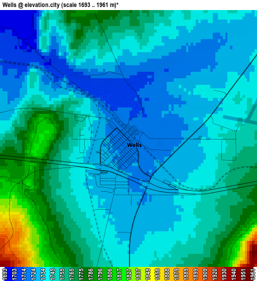
Below is the Elevation map of Wells, which displays elevation range with different colors. Scale of the first map is from 1693 to 1961 m (5554 to 6434 ft) with average elevation of 1748.4 meters (=5736 ft) [note 1]
These maps also provides idea of topography and contour of this city, they are displayed at different zoom levels. More info about maps, scale and edge coordinates you can find below images.
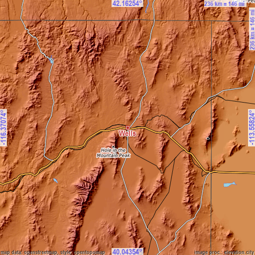
| \ | Map #1 | Topo.Map |
| Scale [m] | 1693..1961 m | × |
| Scale [ft] | 5554..6434 ft | × |
| Average | 1748.4 m = 5736 ft | × |
| Width | 7.36 km = 4.6 mi | 235.6 km = 146.4 mi |
| Height | 7.36 km = 4.6 mi | 235.6 km = 146.4 mi |
| ↑Max Latitude | 41.144691° | 42.16254° |
| Latitude at center | 41.11159° | 41.11159° |
| ↓Min Latitude | 41.078472° | 40.04354° |
| ← Min Longitude | -115.008435° | -116.37074° |
| Longitude center | -114.96449° | -114.96449° |
| →Max Longitude | -114.920545° | -113.55824° |
Nearby cities:
Cities around Wells sort by population:
• Twin Falls elevation 1135 m
166.7 km,  14°
14°
• Elko 1551 m
73.9 km,  245°
245°
• Spring Creek 1725 m
67.5 km,  230°
230°
• West Wendover 1361 m
85.6 km,  118°
118°
• Buhl 1152 m
166.3 km, 5°
• Battle Mountain 1381 m
173.6 km, 252°
• Kimberly 1196 m
165.8 km,  17°
17°
• Filer 1148 m
164.8 km, 10°
• Carlin 1496 m
105.5 km, 245°
• Wendover 1312 m
88.3 km, 118°
• Hansen 1228 m
167.1 km, 19°
• Jackpot 1613 m
99.9 km, 13°
Multilingual:
 En español:
Wells elevación 1720 m.
 En France:
Wells élévation 1720 m.


Sources and notes:
- [note 1] Map square and city borders are not equal. Map elevation data is calculated only from area inside that square.
- [src 1] Elevation data from geonames database provided with same terms of usage.
- [src 2] The elevation map of Wells is generated using elevation data from NASA's 3 arcsec (90m) resolution SRTM data.
- [src 3] Base (background) map © OpenStreetMap contributors tiles are generated by Geofabrik and OpenTopoMap.
Copyright & License:
This Wells Elevation Map is licensed under CC BY-SA. You may reuse any part from this page, if you give a proper credit by linking to this URL:
 More info on terms of use page.