Buhl elevation
Buhl (Idaho, Twin Falls County), United States elevation is 1152 meters and Buhl elevation in feet is 3780 ft above sea level [src 1]. Buhl is a populated place (feature code) with elevation that is 873 meters (2864 ft) bigger than average city elevation in United States.
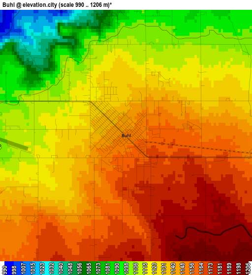
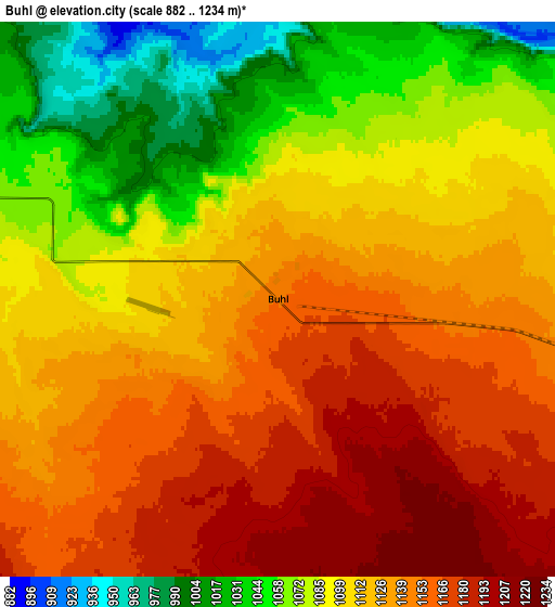
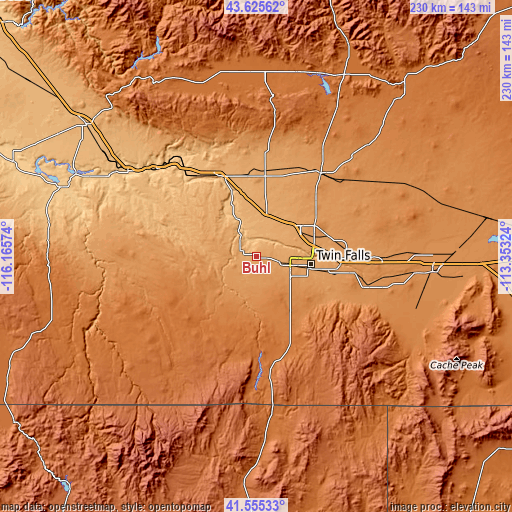
Below is the Elevation map of Buhl, which displays elevation range with different colors. Scale of the first map is from 990 to 1206 m (3248 to 3957 ft) with average elevation of 1133 meters (=3717 ft) [note 1]
These maps also provides idea of topography and contour of this city, they are displayed at different zoom levels. More info about maps, scale and edge coordinates you can find below images.
| \ | Map #1 | Map #2 | Topo.Map |
| Scale [m] | 990..1206 m | 882..1234 m | × |
| Scale [ft] | 3248..3957 ft | 2894..4049 ft | × |
| Average | 1133 m = 3717 ft | 1114.5 m = 3656 ft | × |
| Width | 7.19 km = 4.5 mi | 14.39 km = 8.9 mi | 230.2 km = 143 mi |
| Height | 7.19 km = 4.5 mi | 14.39 km = 8.9 mi | 230.2 km = 143 mi |
| ↑Max Latitude | 42.63141° | 42.663733° | 43.62562° |
| Latitude at center | 42.59907° | 42.59907° | 42.59907° |
| ↓Min Latitude | 42.566713° | 42.534339° | 41.55533° |
| ← Min Longitude | -114.803435° | -114.847381° | -116.16574° |
| Longitude center | -114.75949° | -114.75949° | -114.75949° |
| →Max Longitude | -114.715545° | -114.671599° | -113.35324° |
Nearby cities:
Cities around Buhl sort by population:
• Twin Falls elevation 1135 m
24.8 km,  99°
99°
• Jerome 1149 m
24.1 km,  54°
54°
• Burley 1268 m
79.5 km, 95°
• Kimberly 1196 m
33.1 km, 102°
• Gooding 1091 m
38 km,  5°
5°
• Wendell 1048 m
20.2 km, 12°
• Filer 1148 m
12.8 km, 104°
• Shoshone 1211 m
47.3 km,  37°
37°
• Hansen 1228 m
38.3 km, 101°
• Glenns Ferry 784 m
59.3 km,  311°
311°
• Jackpot 1613 m
68.8 km,  174°
174°
• Paul 1265 m
79.9 km,  89°
89°
Multilingual:
 En español:
Buhl elevación 1152 m.
 En France:
Buhl élévation 1152 m.


Sources and notes:
- [note 1] Map square and city borders are not equal. Map elevation data is calculated only from area inside that square.
- [src 1] Elevation data from geonames database provided with same terms of usage.
- [src 2] The elevation map of Buhl is generated using elevation data from NASA's 3 arcsec (90m) resolution SRTM data.
- [src 3] Base (background) map © OpenStreetMap contributors tiles are generated by Geofabrik and OpenTopoMap.
Copyright & License:
This Buhl Elevation Map is licensed under CC BY-SA. You may reuse any part from this page, if you give a proper credit by linking to this URL:
 More info on terms of use page.