Glenns Ferry elevation
Glenns Ferry (Idaho, Elmore County), United States elevation is 784 meters and Glenns Ferry elevation in feet is 2572 ft above sea level [src 1]. Glenns Ferry is a populated place (feature code) with elevation that is 505 meters (1657 ft) bigger than average city elevation in United States.
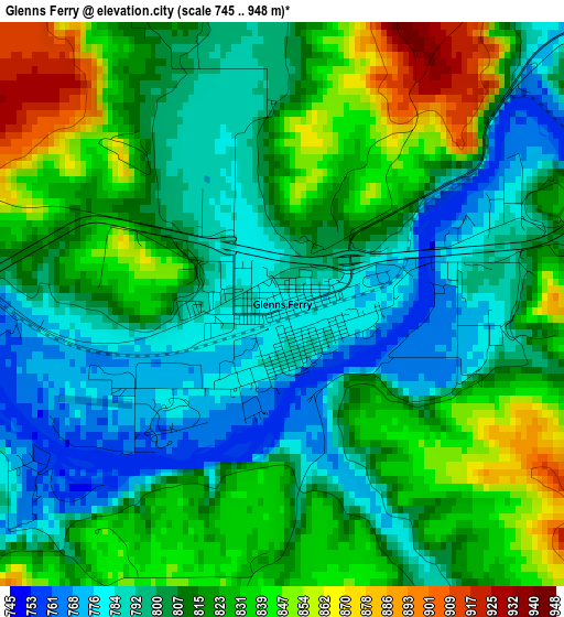
Below is the Elevation map of Glenns Ferry, which displays elevation range with different colors. Scale of the first map is from 745 to 948 m (2444 to 3110 ft) with average elevation of 813.9 meters (=2670 ft) [note 1]
These maps also provides idea of topography and contour of this city, they are displayed at different zoom levels. More info about maps, scale and edge coordinates you can find below images.
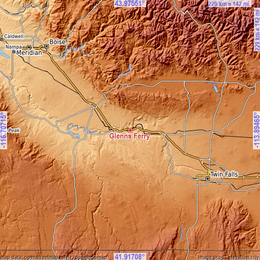
| \ | Map #1 | Topo.Map |
| Scale [m] | 745..948 m | × |
| Scale [ft] | 2444..3110 ft | × |
| Average | 813.9 m = 2670 ft | × |
| Width | 7.15 km = 4.4 mi | 228.9 km = 142.2 mi |
| Height | 7.15 km = 4.4 mi | 228.9 km = 142.2 mi |
| ↑Max Latitude | 42.987055° | 43.97551° |
| Latitude at center | 42.9549° | 42.9549° |
| ↓Min Latitude | 42.922728° | 41.91708° |
| ← Min Longitude | -115.344845° | -116.70715° |
| Longitude center | -115.3009° | -115.3009° |
| →Max Longitude | -115.256955° | -113.89465° |
Nearby cities:
Cities around Glenns Ferry sort by population:
• Twin Falls elevation 1135 m
81.3 km,  122°
122°
• Mountain Home 961 m
37.4 km,  301°
301°
• Jerome 1149 m
68.7 km,  111°
111°
• Buhl 1152 m
59.3 km,  131°
131°
• Kimberly 1196 m
89.6 km, 121°
• Gooding 1091 m
47.9 km,  92°
92°
• Wendell 1048 m
52.5 km, 112°
• Filer 1148 m
70.9 km, 127°
• Bellevue 1579 m
101.5 km,  56°
56°
• Shoshone 1211 m
72.9 km, 91°
• Hansen 1228 m
94.3 km, 120°
• Fairfield 1546 m
60 km,  43°
43°
Multilingual:
 En español:
Glenns Ferry elevación 784 m.
 En France:
Glenns Ferry élévation 784 m.
 Auf Deutsch:
Glenns Ferry höhe über dem Meeresspiegel ist 784 m.

Sources and notes:
- [note 1] Map square and city borders are not equal. Map elevation data is calculated only from area inside that square.
- [src 1] Elevation data from geonames database provided with same terms of usage.
- [src 2] The elevation map of Glenns Ferry is generated using elevation data from NASA's 3 arcsec (90m) resolution SRTM data.
- [src 3] Base (background) map © OpenStreetMap contributors tiles are generated by Geofabrik and OpenTopoMap.
Copyright & License:
This Glenns Ferry Elevation Map is licensed under CC BY-SA. You may reuse any part from this page, if you give a proper credit by linking to this URL:
 More info on terms of use page.