Twin Falls elevation
Twin Falls (Idaho, Twin Falls County), United States elevation is 1135 meters and Twin Falls elevation in feet is 3724 ft above sea level [src 1]. Twin Falls is a seat of a second-order administrative division (feature code) with elevation that is 856 meters (2808 ft) bigger than average city elevation in United States.
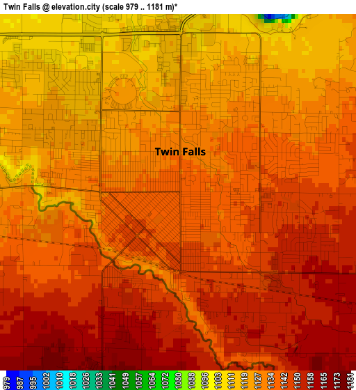
Below is the Elevation map of Twin Falls, which displays elevation range with different colors. Scale of the first map is from 979 to 1181 m (3212 to 3875 ft) with average elevation of 1135.9 meters (=3727 ft) [note 1]
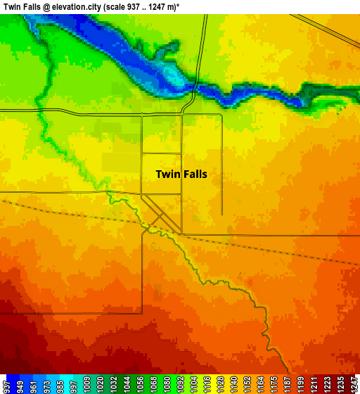
These maps also provides idea of topography and contour of this city, they are displayed at different zoom levels. More info about maps, scale and edge coordinates you can find below images.
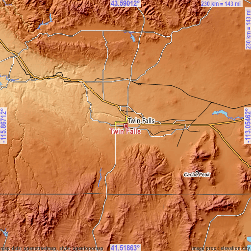
| \ | Map #1 | Map #2 | Topo.Map |
| Scale [m] | 979..1181 m | 937..1247 m | × |
| Scale [ft] | 3212..3875 ft | 3074..4091 ft | × |
| Average | 1135.9 m = 3727 ft | 1139.1 m = 3737 ft | × |
| Width | 7.2 km = 4.5 mi | 14.4 km = 8.9 mi | 230.3 km = 143.1 mi |
| Height | 7.2 km = 4.5 mi | 14.4 km = 8.9 mi | 230.3 km = 143.1 mi |
| ↑Max Latitude | 42.595329° | 42.627671° | 43.59012° |
| Latitude at center | 42.56297° | 42.56297° | 42.56297° |
| ↓Min Latitude | 42.530594° | 42.498202° | 41.51863° |
| ← Min Longitude | -114.504815° | -114.548761° | -115.86712° |
| Longitude center | -114.46087° | -114.46087° | -114.46087° |
| →Max Longitude | -114.416925° | -114.372979° | -113.05462° |
Nearby cities:
Cities around Twin Falls sort by population:
• Jerome elevation 1149 m
18.5 km,  345°
345°
• Burley 1268 m
54.8 km,  93°
93°
• Rupert 1266 m
64.4 km,  84°
84°
• Buhl 1152 m
24.8 km,  279°
279°
• Kimberly 1196 m
8.5 km,  112°
112°
• Gooding 1091 m
46.6 km,  333°
333°
• Heyburn 1264 m
57.1 km, 90°
• Wendell 1048 m
30.9 km,  319°
319°
• Filer 1148 m
12.1 km,  273°
273°
• Shoshone 1211 m
41.7 km,  6°
6°
• Hansen 1228 m
13.6 km, 105°
• Paul 1265 m
55.7 km, 84°
Multilingual:
 En español:
Twin Falls elevación 1135 m.
 En France:
Twin Falls élévation 1135 m.
 Auf Deutsch:
Twin Falls höhe über dem Meeresspiegel ist 1135 m.

Sources and notes:
- [note 1] Map square and city borders are not equal. Map elevation data is calculated only from area inside that square.
- [src 1] Elevation data from geonames database provided with same terms of usage.
- [src 2] The elevation map of Twin Falls is generated using elevation data from NASA's 3 arcsec (90m) resolution SRTM data.
- [src 3] Base (background) map © OpenStreetMap contributors tiles are generated by Geofabrik and OpenTopoMap.
Copyright & License:
This Twin Falls Elevation Map is licensed under CC BY-SA. You may reuse any part from this page, if you give a proper credit by linking to this URL:
 More info on terms of use page.