Wendover elevation
Wendover (Utah, Tooele County), United States elevation is 1312 meters and Wendover elevation in feet is 4304 ft above sea level [src 1]. Wendover is a populated place (feature code) with elevation that is 1033 meters (3389 ft) bigger than average city elevation in United States.
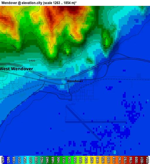
Below is the Elevation map of Wendover, which displays elevation range with different colors. Scale of the first map is from 1263 to 1854 m (4144 to 6083 ft) with average elevation of 1368.1 meters (=4489 ft) [note 1]
These maps also provides idea of topography and contour of this city, they are displayed at different zoom levels. More info about maps, scale and edge coordinates you can find below images.
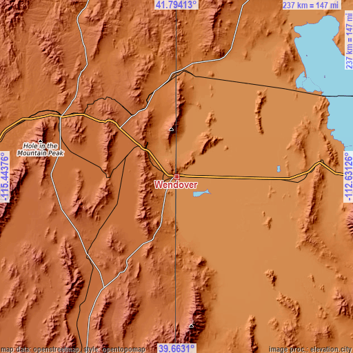
| \ | Map #1 | Topo.Map |
| Scale [m] | 1263..1854 m | × |
| Scale [ft] | 4144..6083 ft | × |
| Average | 1368.1 m = 4489 ft | × |
| Width | 7.4 km = 4.6 mi | 236.9 km = 147.2 mi |
| Height | 7.4 km = 4.6 mi | 236.9 km = 147.2 mi |
| ↑Max Latitude | 40.77044° | 41.79413° |
| Latitude at center | 40.73715° | 40.73715° |
| ↓Min Latitude | 40.703844° | 39.6631° |
| ← Min Longitude | -114.081455° | -115.44376° |
| Longitude center | -114.03751° | -114.03751° |
| →Max Longitude | -113.993565° | -112.63126° |
Nearby cities:
Cities around Wendover sort by population:
• Tooele elevation 1540 m
148.5 km,  98°
98°
• Magna 1312 m
163.2 km,  91°
91°
• Elko 1551 m
145.7 km,  274°
274°
• Spring Creek 1725 m
130.5 km, 269°
• Grantsville 1315 m
133.5 km, 96°
• Hooper 1295 m
167.7 km,  73°
73°
• Stansbury park 1310 m
147.2 km, 94°
• Erda 1327 m
146.8 km, 95°
• West Wendover 1361 m
3 km, 274°
• Wells 1720 m
88.3 km,  298°
298°
• Jackpot 1613 m
148.4 km,  339°
339°
• McGill 1899 m
161 km,  203°
203°
Multilingual:
 En español:
Wendover elevación 1312 m.
 En France:
Wendover élévation 1312 m.
 Auf Deutsch:
Wendover höhe über dem Meeresspiegel ist 1312 m.

Sources and notes:
- [note 1] Map square and city borders are not equal. Map elevation data is calculated only from area inside that square.
- [src 1] Elevation data from geonames database provided with same terms of usage.
- [src 2] The elevation map of Wendover is generated using elevation data from NASA's 3 arcsec (90m) resolution SRTM data.
- [src 3] Base (background) map © OpenStreetMap contributors tiles are generated by Geofabrik and OpenTopoMap.
Copyright & License:
This Wendover Elevation Map is licensed under CC BY-SA. You may reuse any part from this page, if you give a proper credit by linking to this URL:
 More info on terms of use page.