Erda elevation
Erda (Utah, Tooele County), United States elevation is 1327 meters and Erda elevation in feet is 4354 ft above sea level [src 1]. Erda is a populated place (feature code) with elevation that is 1048 meters (3438 ft) bigger than average city elevation in United States.
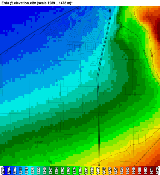
Below is the Elevation map of Erda, which displays elevation range with different colors. Scale of the first map is from 1289 to 1478 m (4229 to 4849 ft) with average elevation of 1345.8 meters (=4415 ft) [note 1]
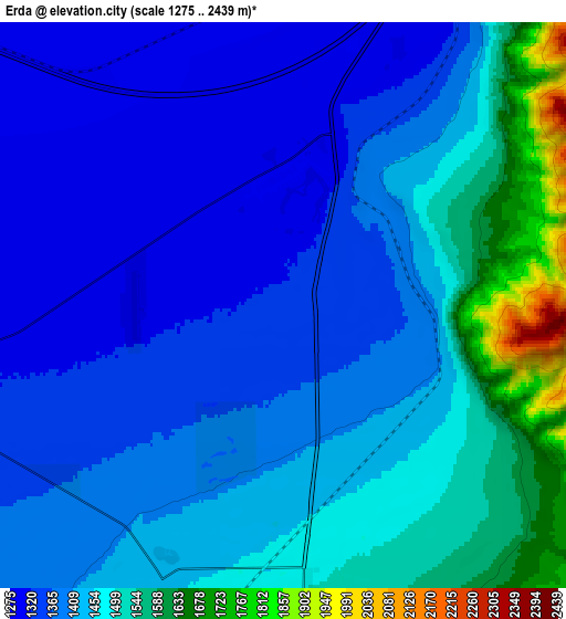
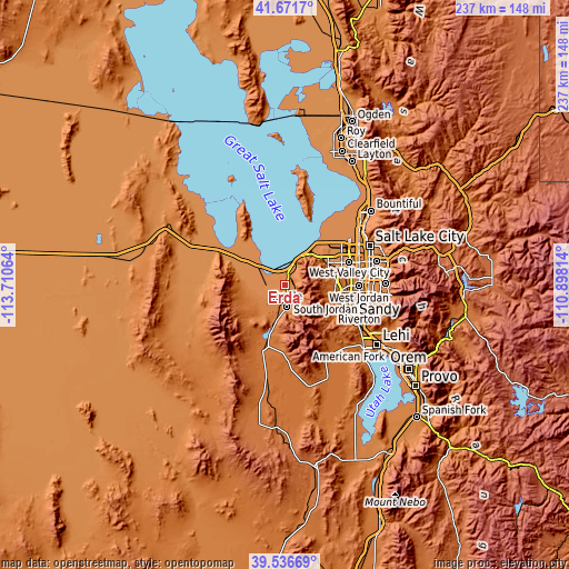
These maps also provides idea of topography and contour of this city, they are displayed at different zoom levels. More info about maps, scale and edge coordinates you can find below images.
| \ | Map #1 | Map #2 | Topo.Map |
| Scale [m] | 1289..1478 m | 1275..2439 m | × |
| Scale [ft] | 4229..4849 ft | 4183..8002 ft | × |
| Average | 1345.8 m = 4415 ft | 1428.5 m = 4687 ft | × |
| Width | 7.42 km = 4.6 mi | 14.84 km = 9.2 mi | 237.4 km = 147.5 mi |
| Height | 7.42 km = 4.6 mi | 14.84 km = 9.2 mi | 237.4 km = 147.5 mi |
| ↑Max Latitude | 40.646072° | 40.679407° | 41.6717° |
| Latitude at center | 40.61272° | 40.61272° | 40.61272° |
| ↓Min Latitude | 40.579352° | 40.545967° | 39.53669° |
| ← Min Longitude | -112.348335° | -112.392281° | -113.71064° |
| Longitude center | -112.30439° | -112.30439° | -112.30439° |
| →Max Longitude | -112.260445° | -112.216499° | -110.89814° |
Nearby cities:
Cities around Erda sort by population:
• West Valley City elevation 1316 m
27.1 km,  71°
71°
• West Jordan 1338 m
30.8 km,  90°
90°
• South Jordan 1358 m
32.1 km,  100°
100°
• Taylorsville 1314 m
31.4 km,  78°
78°
• South Jordan Heights 1381 m
30.5 km, 100°
• Kearns 1385 m
26.5 km, 78°
• Tooele 1540 m
9.1 km,  176°
176°
• Herriman 1511 m
25.4 km,  115°
115°
• Magna 1312 m
20.2 km,  57°
57°
• Oquirrh 1504 m
22.9 km, 85°
• Grantsville 1315 m
13.6 km,  263°
263°
• Stansbury park 1310 m
2.9 km,  14°
14°
Multilingual:
 En español:
Erda elevación 1327 m.
 En France:
Erda élévation 1327 m.


Sources and notes:
- [note 1] Map square and city borders are not equal. Map elevation data is calculated only from area inside that square.
- [src 1] Elevation data from geonames database provided with same terms of usage.
- [src 2] The elevation map of Erda is generated using elevation data from NASA's 3 arcsec (90m) resolution SRTM data.
- [src 3] Base (background) map © OpenStreetMap contributors tiles are generated by Geofabrik and OpenTopoMap.
Copyright & License:
This Erda Elevation Map is licensed under CC BY-SA. You may reuse any part from this page, if you give a proper credit by linking to this URL:
 More info on terms of use page.