Taylorsville elevation
Taylorsville (Utah, Salt Lake County), United States elevation is 1314 meters and Taylorsville elevation in feet is 4311 ft above sea level [src 1]. Taylorsville is a populated place (feature code) with elevation that is 1035 meters (3396 ft) bigger than average city elevation in United States.
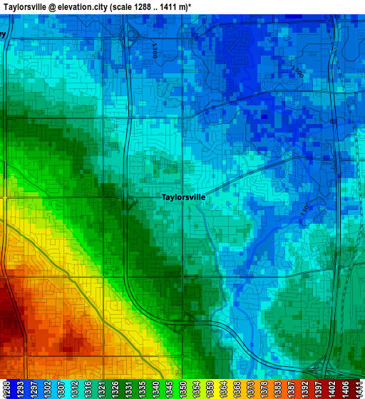
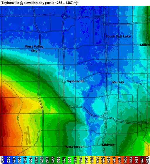
Below is the Elevation map of Taylorsville, which displays elevation range with different colors. Scale of the first map is from 1288 to 1411 m (4226 to 4629 ft) with average elevation of 1321.9 meters (=4337 ft) [note 1]
These maps also provides idea of topography and contour of this city, they are displayed at different zoom levels. More info about maps, scale and edge coordinates you can find below images.
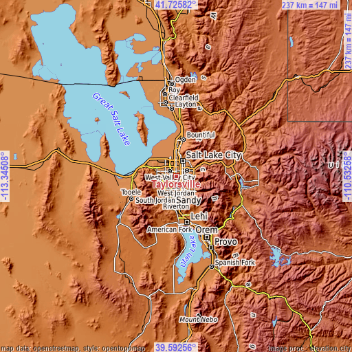
| \ | Map #1 | Map #2 | Topo.Map |
| Scale [m] | 1288..1411 m | 1285..1487 m | × |
| Scale [ft] | 4226..4629 ft | 4216..4879 ft | × |
| Average | 1321.9 m = 4337 ft | 1335.5 m = 4382 ft | × |
| Width | 7.41 km = 4.6 mi | 14.83 km = 9.2 mi | 237.2 km = 147.4 mi |
| Height | 7.41 km = 4.6 mi | 14.82 km = 9.2 mi | 237.2 km = 147.4 mi |
| ↑Max Latitude | 40.701044° | 40.734352° | 41.72582° |
| Latitude at center | 40.66772° | 40.66772° | 40.66772° |
| ↓Min Latitude | 40.634379° | 40.601022° | 39.59256° |
| ← Min Longitude | -111.982775° | -112.026721° | -113.34508° |
| Longitude center | -111.93883° | -111.93883° | -111.93883° |
| →Max Longitude | -111.894885° | -111.850939° | -110.53258° |
Nearby cities:
Cities around Taylorsville sort by population:
• West Valley City elevation 1316 m
5.9 km,  296°
296°
• West Jordan 1338 m
6.5 km,  180°
180°
• Sandy 1366 m
9.6 km,  151°
151°
• Millcreek 1309 m
5.8 km,  68°
68°
• Murray 1317 m
4.3 km,  91°
91°
• Kearns 1385 m
4.9 km,  259°
259°
• Midvale 1341 m
7.1 km, 152°
• Holladay 1363 m
9.6 km, 89°
• South Salt Lake 1299 m
7.1 km,  36°
36°
• Oquirrh 1504 m
9 km,  242°
242°
• Willard 1378 m
9.6 km,  63°
63°
• Centerfield 1300 m
4.3 km,  52°
52°
Multilingual:
 En español:
Taylorsville elevación 1314 m.
 En France:
Taylorsville élévation 1314 m.
 Auf Deutsch:
Taylorsville höhe über dem Meeresspiegel ist 1314 m.

Sources and notes:
- [note 1] Map square and city borders are not equal. Map elevation data is calculated only from area inside that square.
- [src 1] Elevation data from geonames database provided with same terms of usage.
- [src 2] The elevation map of Taylorsville is generated using elevation data from NASA's 3 arcsec (90m) resolution SRTM data.
- [src 3] Base (background) map © OpenStreetMap contributors tiles are generated by Geofabrik and OpenTopoMap.
Copyright & License:
This Taylorsville Elevation Map is licensed under CC BY-SA. You may reuse any part from this page, if you give a proper credit by linking to this URL:
 More info on terms of use page.