McCall elevation
McCall (Idaho, Valley County), United States elevation is 1531 meters and McCall elevation in feet is 5023 ft above sea level [src 1]. McCall is a populated place (feature code) with elevation that is 1252 meters (4108 ft) bigger than average city elevation in United States.
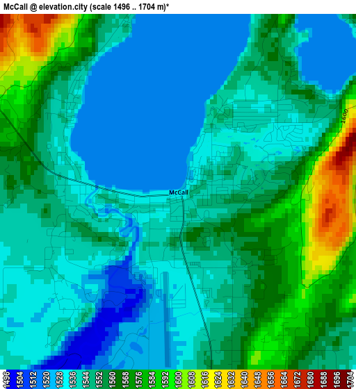
Below is the Elevation map of McCall, which displays elevation range with different colors. Scale of the first map is from 1496 to 1704 m (4908 to 5591 ft) with average elevation of 1549 meters (=5082 ft) [note 1]
These maps also provides idea of topography and contour of this city, they are displayed at different zoom levels. More info about maps, scale and edge coordinates you can find below images.
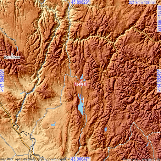
| \ | Map #1 | Topo.Map |
| Scale [m] | 1496..1704 m | × |
| Scale [ft] | 4908..5591 ft | × |
| Average | 1549 m = 5082 ft | × |
| Width | 6.92 km = 4.3 mi | 221.5 km = 137.6 mi |
| Height | 6.92 km = 4.3 mi | 221.5 km = 137.6 mi |
| ↑Max Latitude | 44.942124° | 45.89829° |
| Latitude at center | 44.91101° | 44.91101° |
| ↓Min Latitude | 44.879879° | 43.90647° |
| ← Min Longitude | -116.142685° | -117.50499° |
| Longitude center | -116.09874° | -116.09874° |
| →Max Longitude | -116.054795° | -114.69249° |
Nearby cities:
Cities around McCall sort by population:
• Ontario elevation 655 m
119.9 km,  214°
214°
• Payette 659 m
113.8 km,  215°
215°
• Emmett 725 m
119.7 km,  195°
195°
• Weiser 651 m
100.7 km, 223°
• Fruitland 677 m
119.6 km, 212°
• Grangeville 1034 m
112.9 km,  359°
359°
• Enterprise 1143 m
108.8 km,  301°
301°
• New Plymouth 689 m
119.2 km, 208°
• Joseph 1274 m
101.5 km, 299°
• Cascade 1449 m
44.1 km,  174°
174°
• Council 899 m
33.5 km,  233°
233°
• Idaho City 1190 m
122.2 km, 170°
Multilingual:
 En español:
McCall elevación 1531 m.
 En France:
McCall élévation 1531 m.


Sources and notes:
- [note 1] Map square and city borders are not equal. Map elevation data is calculated only from area inside that square.
- [src 1] Elevation data from geonames database provided with same terms of usage.
- [src 2] The elevation map of McCall is generated using elevation data from NASA's 3 arcsec (90m) resolution SRTM data.
- [src 3] Base (background) map © OpenStreetMap contributors tiles are generated by Geofabrik and OpenTopoMap.
Copyright & License:
This McCall Elevation Map is licensed under CC BY-SA. You may reuse any part from this page, if you give a proper credit by linking to this URL:
 More info on terms of use page.