Grangeville elevation
Grangeville (Idaho, Idaho County), United States elevation is 1034 meters and Grangeville elevation in feet is 3392 ft above sea level [src 1]. Grangeville is a seat of a second-order administrative division (feature code) with elevation that is 755 meters (2477 ft) bigger than average city elevation in United States.
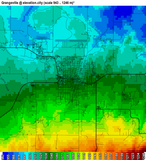
Below is the Elevation map of Grangeville, which displays elevation range with different colors. Scale of the first map is from 943 to 1246 m (3094 to 4088 ft) with average elevation of 1043.7 meters (=3424 ft) [note 1]
These maps also provides idea of topography and contour of this city, they are displayed at different zoom levels. More info about maps, scale and edge coordinates you can find below images.
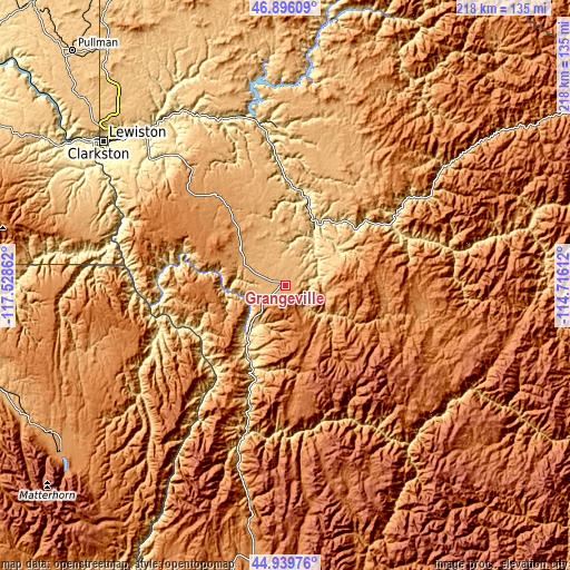
| \ | Map #1 | Topo.Map |
| Scale [m] | 943..1246 m | × |
| Scale [ft] | 3094..4088 ft | × |
| Average | 1043.7 m = 3424 ft | × |
| Width | 6.8 km = 4.2 mi | 217.5 km = 135.1 mi |
| Height | 6.8 km = 4.2 mi | 217.5 km = 135.1 mi |
| ↑Max Latitude | 45.957109° | 46.89609° |
| Latitude at center | 45.92655° | 45.92655° |
| ↓Min Latitude | 45.895974° | 44.93976° |
| ← Min Longitude | -116.166315° | -117.52862° |
| Longitude center | -116.12237° | -116.12237° |
| →Max Longitude | -116.078425° | -114.71612° |
Nearby cities:
Cities around Grangeville sort by population:
• Lewiston elevation 225 m
87.9 km,  308°
308°
• Lewiston Orchards 435 m
82.9 km, 307°
• Clarkston 244 m
89.5 km, 307°
• Clarkston Heights-Vineland 362 m
90 km,  304°
304°
• West Clarkston-Highland 288 m
89.8 km, 306°
• Orofino 310 m
62.3 km,  350°
350°
• Enterprise 1143 m
105.7 km,  238°
238°
• Asotin 243 m
84.8 km, 302°
• Kamiah 376 m
34.2 km,  12°
12°
• Lapwai 289 m
74.8 km,  315°
315°
• Joseph 1274 m
107 km,  233°
233°
• Nezperce 972 m
35.5 km, 345°
Multilingual:
 En español:
Grangeville elevación 1034 m.
 En France:
Grangeville élévation 1034 m.
 Auf Deutsch:
Grangeville höhe über dem Meeresspiegel ist 1034 m.

Sources and notes:
- [note 1] Map square and city borders are not equal. Map elevation data is calculated only from area inside that square.
- [src 1] Elevation data from geonames database provided with same terms of usage.
- [src 2] The elevation map of Grangeville is generated using elevation data from NASA's 3 arcsec (90m) resolution SRTM data.
- [src 3] Base (background) map © OpenStreetMap contributors tiles are generated by Geofabrik and OpenTopoMap.
Copyright & License:
This Grangeville Elevation Map is licensed under CC BY-SA. You may reuse any part from this page, if you give a proper credit by linking to this URL:
 More info on terms of use page.