Lewiston elevation
Lewiston (Idaho, Nez Perce County), United States elevation is 225 meters and Lewiston elevation in feet is 738 ft above sea level [src 1]. Lewiston is a seat of a second-order administrative division (feature code) with elevation that is 54 meters (177 ft) smaller than average city elevation in United States.
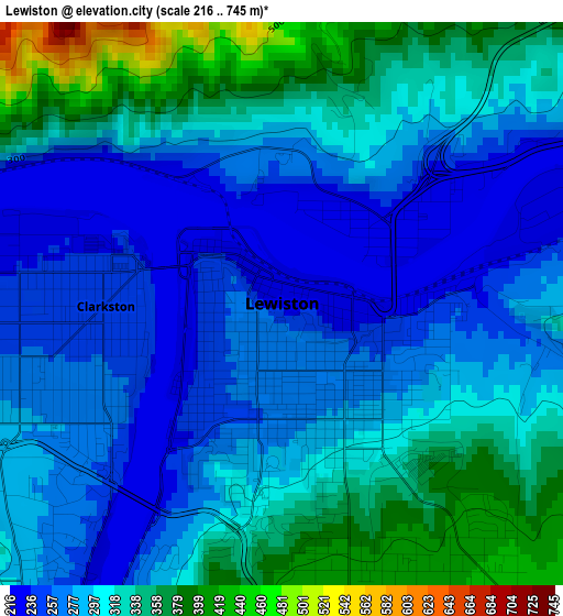
Below is the Elevation map of Lewiston, which displays elevation range with different colors. Scale of the first map is from 216 to 745 m (709 to 2444 ft) with average elevation of 300.5 meters (=986 ft) [note 1]
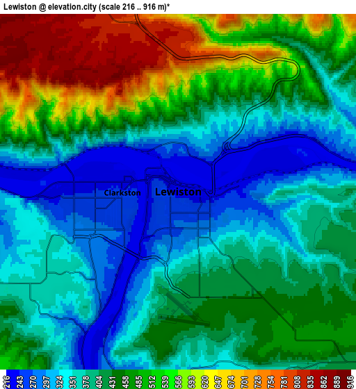
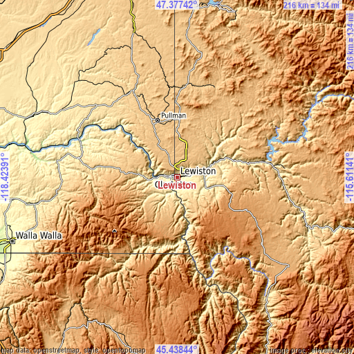
These maps also provides idea of topography and contour of this city, they are displayed at different zoom levels. More info about maps, scale and edge coordinates you can find below images.
| \ | Map #1 | Map #2 | Topo.Map |
| Scale [m] | 216..745 m | 216..916 m | × |
| Scale [ft] | 709..2444 ft | 709..3005 ft | × |
| Average | 300.5 m = 986 ft | 428.9 m = 1407 ft | × |
| Width | 6.74 km = 4.2 mi | 13.47 km = 8.4 mi | 215.6 km = 134 mi |
| Height | 6.74 km = 4.2 mi | 13.47 km = 8.4 mi | 215.6 km = 134 mi |
| ↑Max Latitude | 46.446838° | 46.477109° | 47.37742° |
| Latitude at center | 46.41655° | 46.41655° | 46.41655° |
| ↓Min Latitude | 46.386245° | 46.355924° | 45.43844° |
| ← Min Longitude | -117.061605° | -117.105551° | -118.42391° |
| Longitude center | -117.01766° | -117.01766° | -117.01766° |
| →Max Longitude | -116.973715° | -116.929769° | -115.61141° |
Nearby cities:
Cities around Lewiston sort by population:
• Pullman elevation 713 m
37.1 km,  340°
340°
• Lewiston Orchards 435 m
5.2 km,  141°
141°
• Moscow 788 m
35.1 km,  2°
2°
• Clarkston 244 m
2.1 km,  269°
269°
• Clarkston Heights-Vineland 362 m
6 km,  237°
237°
• West Clarkston-Highland 288 m
3.9 km,  246°
246°
• Orofino 310 m
58.8 km,  83°
83°
• Colfax 602 m
57.9 km,  332°
332°
• Pomeroy 565 m
45.3 km,  278°
278°
• Asotin 243 m
8.9 km,  195°
195°
• Lapwai 289 m
16.4 km,  94°
94°
• Palouse 739 m
55.1 km,  355°
355°
Multilingual:
 En español:
Lewiston elevación 225 m.
 En France:
Lewiston élévation 225 m.
 Auf Deutsch:
Lewiston höhe über dem Meeresspiegel ist 225 m.

Sources and notes:
- [note 1] Map square and city borders are not equal. Map elevation data is calculated only from area inside that square.
- [src 1] Elevation data from geonames database provided with same terms of usage.
- [src 2] The elevation map of Lewiston is generated using elevation data from NASA's 3 arcsec (90m) resolution SRTM data.
- [src 3] Base (background) map © OpenStreetMap contributors tiles are generated by Geofabrik and OpenTopoMap.
Copyright & License:
This Lewiston Elevation Map is licensed under CC BY-SA. You may reuse any part from this page, if you give a proper credit by linking to this URL:
 More info on terms of use page.