Ontario elevation
Ontario (Oregon, Malheur County), United States elevation is 655 meters and Ontario elevation in feet is 2149 ft above sea level [src 1]. Ontario is a populated place (feature code) with elevation that is 376 meters (1234 ft) bigger than average city elevation in United States.
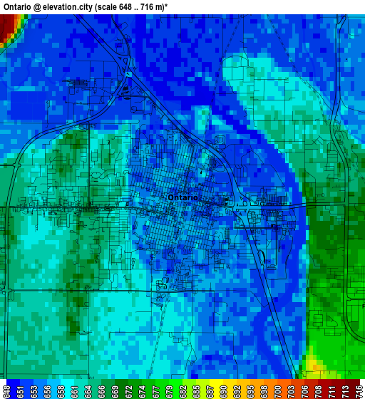
Below is the Elevation map of Ontario, which displays elevation range with different colors. Scale of the first map is from 648 to 716 m (2126 to 2349 ft) with average elevation of 658.8 meters (=2161 ft) [note 1]
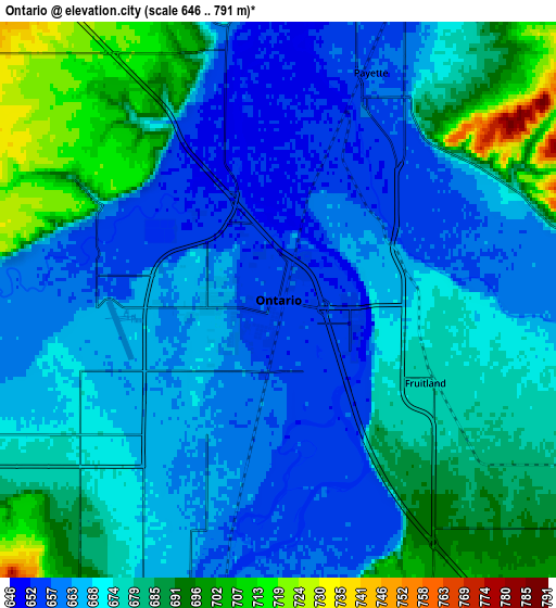
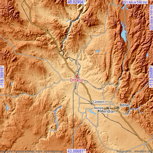
These maps also provides idea of topography and contour of this city, they are displayed at different zoom levels. More info about maps, scale and edge coordinates you can find below images.
| \ | Map #1 | Map #2 | Topo.Map |
| Scale [m] | 648..716 m | 646..791 m | × |
| Scale [ft] | 2126..2349 ft | 2119..2595 ft | × |
| Average | 658.8 m = 2161 ft | 673.7 m = 2210 ft | × |
| Width | 7.03 km = 4.4 mi | 14.05 km = 8.7 mi | 224.9 km = 139.7 mi |
| Height | 7.03 km = 4.4 mi | 14.05 km = 8.7 mi | 224.8 km = 139.7 mi |
| ↑Max Latitude | 44.058139° | 44.089711° | 45.02904° |
| Latitude at center | 44.02655° | 44.02655° | 44.02655° |
| ↓Min Latitude | 43.994944° | 43.963321° | 43.00681° |
| ← Min Longitude | -117.006885° | -117.050831° | -118.36919° |
| Longitude center | -116.96294° | -116.96294° | -116.96294° |
| →Max Longitude | -116.918995° | -116.875049° | -115.55669° |
Nearby cities:
Cities around Ontario sort by population:
• Caldwell elevation 723 m
46.1 km,  151°
151°
• Payette 659 m
6.2 km,  22°
22°
• Middleton 732 m
44.9 km,  142°
142°
• Emmett 725 m
40.8 km,  114°
114°
• Weiser 651 m
25 km,  358°
358°
• Fruitland 677 m
4.3 km,  119°
119°
• Nyssa 664 m
16.8 km,  188°
188°
• Homedale 681 m
45.5 km,  177°
177°
• Parma 681 m
26.9 km, 176°
• Vale 683 m
22.6 km,  257°
257°
• Wilder 740 m
39.1 km,  173°
173°
• New Plymouth 689 m
13.1 km, 118°
Multilingual:
 En español:
Ontario elevación 655 m.
 En France:
Ontario élévation 655 m.


Sources and notes:
- [note 1] Map square and city borders are not equal. Map elevation data is calculated only from area inside that square.
- [src 1] Elevation data from geonames database provided with same terms of usage.
- [src 2] The elevation map of Ontario is generated using elevation data from NASA's 3 arcsec (90m) resolution SRTM data.
- [src 3] Base (background) map © OpenStreetMap contributors tiles are generated by Geofabrik and OpenTopoMap.
Copyright & License:
This Ontario Elevation Map is licensed under CC BY-SA. You may reuse any part from this page, if you give a proper credit by linking to this URL:
 More info on terms of use page.