Weiser elevation
Weiser (Idaho, Washington County), United States elevation is 651 meters and Weiser elevation in feet is 2136 ft above sea level [src 1]. Weiser is a seat of a second-order administrative division (feature code) with elevation that is 372 meters (1220 ft) bigger than average city elevation in United States.
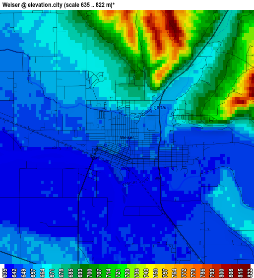
Below is the Elevation map of Weiser, which displays elevation range with different colors. Scale of the first map is from 635 to 822 m (2083 to 2697 ft) with average elevation of 665.2 meters (=2182 ft) [note 1]
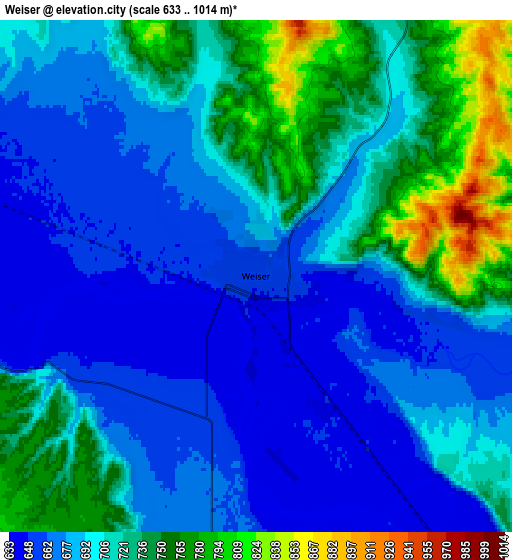
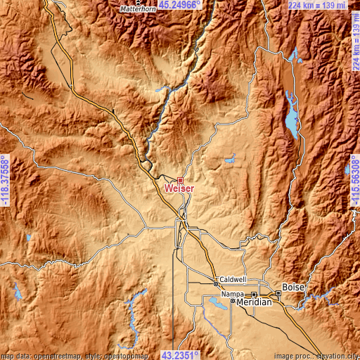
These maps also provides idea of topography and contour of this city, they are displayed at different zoom levels. More info about maps, scale and edge coordinates you can find below images.
| \ | Map #1 | Map #2 | Topo.Map |
| Scale [m] | 635..822 m | 633..1014 m | × |
| Scale [ft] | 2083..2697 ft | 2077..3327 ft | × |
| Average | 665.2 m = 2182 ft | 700.7 m = 2299 ft | × |
| Width | 7 km = 4.3 mi | 14 km = 8.7 mi | 224 km = 139.2 mi |
| Height | 7 km = 4.3 mi | 14 km = 8.7 mi | 224 km = 139.2 mi |
| ↑Max Latitude | 44.282469° | 44.313921° | 45.24966° |
| Latitude at center | 44.251° | 44.251° | 44.251° |
| ↓Min Latitude | 44.219514° | 44.188011° | 43.2351° |
| ← Min Longitude | -117.013275° | -117.057221° | -118.37558° |
| Longitude center | -116.96933° | -116.96933° | -116.96933° |
| →Max Longitude | -116.925385° | -116.881439° | -115.56308° |
Nearby cities:
Cities around Weiser sort by population:
• Caldwell elevation 723 m
69.2 km,  160°
160°
• Ontario 655 m
25 km,  178°
178°
• Payette 659 m
19.4 km,  171°
171°
• Middleton 732 m
66.6 km, 155°
• Emmett 725 m
56.3 km,  138°
138°
• Fruitland 677 m
27.4 km, 171°
• Nyssa 664 m
41.7 km, 182°
• Parma 681 m
51.8 km, 177°
• Vale 683 m
36.8 km,  215°
215°
• Wilder 740 m
64 km, 175°
• New Plymouth 689 m
33.5 km, 159°
• Council 899 m
67.9 km,  38°
38°
Multilingual:
 En español:
Weiser elevación 651 m.
 En France:
Weiser élévation 651 m.


Sources and notes:
- [note 1] Map square and city borders are not equal. Map elevation data is calculated only from area inside that square.
- [src 1] Elevation data from geonames database provided with same terms of usage.
- [src 2] The elevation map of Weiser is generated using elevation data from NASA's 3 arcsec (90m) resolution SRTM data.
- [src 3] Base (background) map © OpenStreetMap contributors tiles are generated by Geofabrik and OpenTopoMap.
Copyright & License:
This Weiser Elevation Map is licensed under CC BY-SA. You may reuse any part from this page, if you give a proper credit by linking to this URL:
 More info on terms of use page.