La Junta elevation
La Junta (Colorado, Otero County), United States elevation is 1245 meters and La Junta elevation in feet is 4085 ft above sea level [src 1]. La Junta is a seat of a second-order administrative division (feature code) with elevation that is 966 meters (3169 ft) bigger than average city elevation in United States.
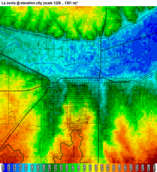
Below is the Elevation map of La Junta, which displays elevation range with different colors. Scale of the first map is from 1226 to 1301 m (4022 to 4268 ft) with average elevation of 1256.8 meters (=4123 ft) [note 1]
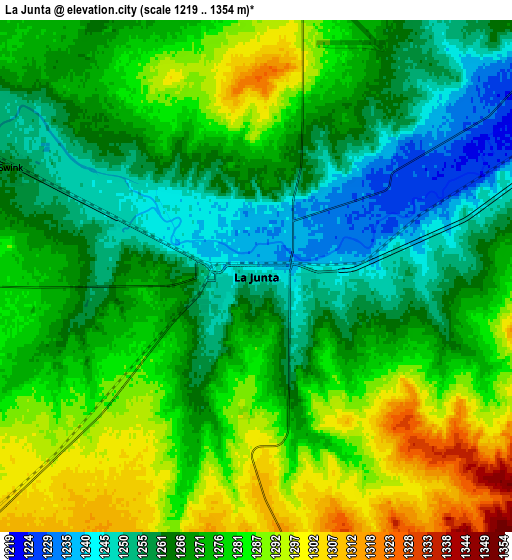
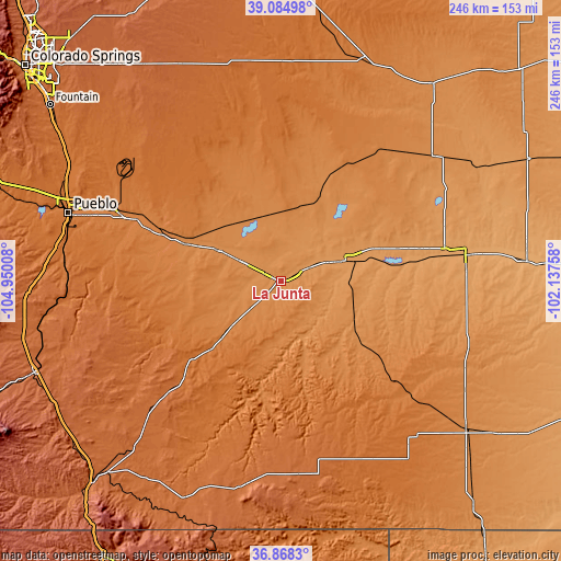
These maps also provides idea of topography and contour of this city, they are displayed at different zoom levels. More info about maps, scale and edge coordinates you can find below images.
| \ | Map #1 | Map #2 | Topo.Map |
| Scale [m] | 1226..1301 m | 1219..1354 m | × |
| Scale [ft] | 4022..4268 ft | 3999..4442 ft | × |
| Average | 1256.8 m = 4123 ft | 1272.8 m = 4176 ft | × |
| Width | 7.7 km = 4.8 mi | 15.4 km = 9.6 mi | 246.5 km = 153.2 mi |
| Height | 7.7 km = 4.8 mi | 15.4 km = 9.6 mi | 246.5 km = 153.2 mi |
| ↑Max Latitude | 38.019638° | 38.05425° | 39.08498° |
| Latitude at center | 37.98501° | 37.98501° | 37.98501° |
| ↓Min Latitude | 37.950365° | 37.915704° | 36.8683° |
| ← Min Longitude | -103.587775° | -103.631721° | -104.95008° |
| Longitude center | -103.54383° | -103.54383° | -103.54383° |
| →Max Longitude | -103.499885° | -103.455939° | -102.13758° |
Nearby cities:
Cities around La Junta sort by population:
• Pueblo elevation 1430 m
97.9 km,  287°
287°
• Pueblo West 1548 m
110.8 km, 291°
• Lamar 1107 m
81.6 km,  81°
81°
• Rocky Ford 1276 m
17.2 km,  295°
295°
• Walsenburg 1884 m
115.8 km,  249°
249°
• Las Animas 1192 m
29.6 km,  72°
72°
• Colorado City 1788 m
113.3 km,  267°
267°
• Springfield 1331 m
103.9 km,  128°
128°
• Fowler 1328 m
44.9 km, 290°
• Ellicott 1838 m
120 km,  322°
322°
• Ordway 1317 m
31.9 km, 324°
• Eads 1289 m
86.4 km,  50°
50°
Multilingual:
 En español:
La Junta elevación 1245 m.
 En France:
La Junta élévation 1245 m.
 Auf Deutsch:
La Junta höhe über dem Meeresspiegel ist 1245 m.

Sources and notes:
- [note 1] Map square and city borders are not equal. Map elevation data is calculated only from area inside that square.
- [src 1] Elevation data from geonames database provided with same terms of usage.
- [src 2] The elevation map of La Junta is generated using elevation data from NASA's 3 arcsec (90m) resolution SRTM data.
- [src 3] Base (background) map © OpenStreetMap contributors tiles are generated by Geofabrik and OpenTopoMap.
Copyright & License:
This La Junta Elevation Map is licensed under CC BY-SA. You may reuse any part from this page, if you give a proper credit by linking to this URL:
 More info on terms of use page.