Springfield elevation
Springfield (Colorado, Baca County), United States elevation is 1331 meters and Springfield elevation in feet is 4367 ft above sea level [src 1]. Springfield is a seat of a second-order administrative division (feature code) with elevation that is 1052 meters (3451 ft) bigger than average city elevation in United States.
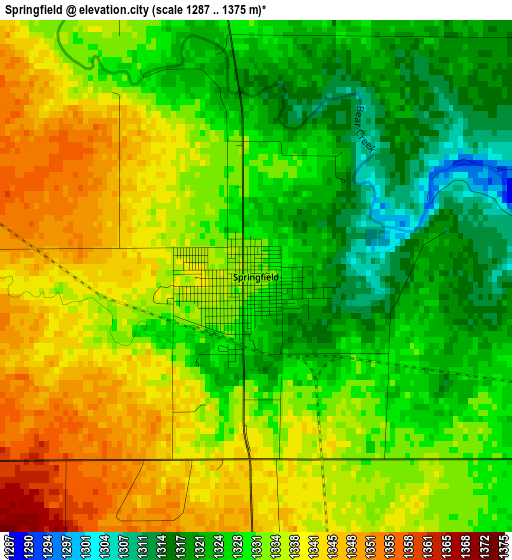
Below is the Elevation map of Springfield, which displays elevation range with different colors. Scale of the first map is from 1287 to 1375 m (4222 to 4511 ft) with average elevation of 1331.9 meters (=4370 ft) [note 1]
These maps also provides idea of topography and contour of this city, they are displayed at different zoom levels. More info about maps, scale and edge coordinates you can find below images.
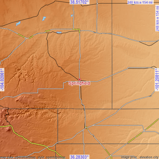
| \ | Map #1 | Topo.Map |
| Scale [m] | 1287..1375 m | × |
| Scale [ft] | 4222..4511 ft | × |
| Average | 1331.9 m = 4370 ft | × |
| Width | 7.76 km = 4.8 mi | 248.4 km = 154.3 mi |
| Height | 7.76 km = 4.8 mi | 248.4 km = 154.3 mi |
| ↑Max Latitude | 37.443249° | 38.51702° |
| Latitude at center | 37.40835° | 37.40835° |
| ↓Min Latitude | 37.373435° | 36.28303° |
| ← Min Longitude | -102.658305° | -104.02061° |
| Longitude center | -102.61436° | -102.61436° |
| →Max Longitude | -102.570415° | -101.20811° |
Nearby cities:
Cities around Springfield sort by population:
• Lamar elevation 1107 m
75.5 km,  359°
359°
• La Junta 1245 m
103.9 km,  308°
308°
• Ulysses 933 m
112.7 km,  80°
80°
• Hugoton 951 m
114.8 km,  103°
103°
• Rocky Ford 1276 m
120.8 km, 306°
• Clayton 1542 m
117.8 km,  205°
205°
• Las Animas 1192 m
90.7 km,  323°
323°
• Elkhart 1091 m
78.1 km,  124°
124°
• Syracuse 989 m
98.9 km,  49°
49°
• Johnson 1019 m
78.3 km, 76°
• Boise City 1272 m
76 km,  173°
173°
• Eads 1289 m
120.1 km,  352°
352°
Multilingual:
 En español:
Springfield elevación 1331 m.
 En France:
Springfield élévation 1331 m.
 Auf Deutsch:
Springfield höhe über dem Meeresspiegel ist 1331 m.

Sources and notes:
- [note 1] Map square and city borders are not equal. Map elevation data is calculated only from area inside that square.
- [src 1] Elevation data from geonames database provided with same terms of usage.
- [src 2] The elevation map of Springfield is generated using elevation data from NASA's 3 arcsec (90m) resolution SRTM data.
- [src 3] Base (background) map © OpenStreetMap contributors tiles are generated by Geofabrik and OpenTopoMap.
Copyright & License:
This Springfield Elevation Map is licensed under CC BY-SA. You may reuse any part from this page, if you give a proper credit by linking to this URL:
 More info on terms of use page.