Hugoton elevation
Hugoton (Kansas, Stevens County), United States elevation is 951 meters and Hugoton elevation in feet is 3120 ft above sea level [src 1]. Hugoton is a seat of a second-order administrative division (feature code) with elevation that is 672 meters (2205 ft) bigger than average city elevation in United States.
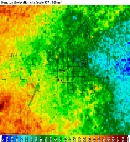
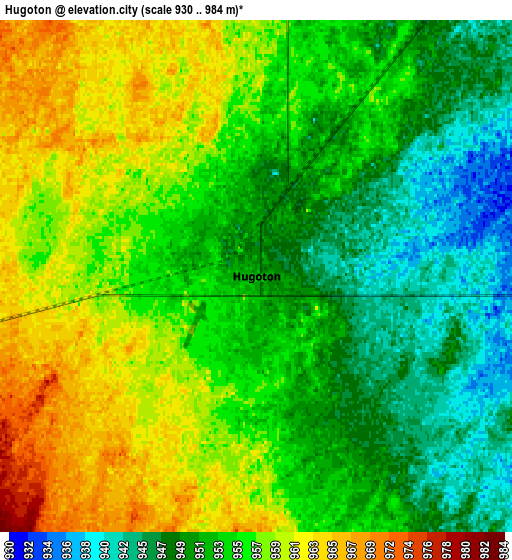
Below is the Elevation map of Hugoton, which displays elevation range with different colors. Scale of the first map is from 937 to 969 m (3074 to 3179 ft) with average elevation of 952 meters (=3123 ft) [note 1]
These maps also provides idea of topography and contour of this city, they are displayed at different zoom levels. More info about maps, scale and edge coordinates you can find below images.
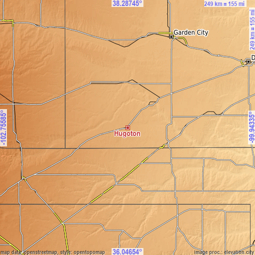
| \ | Map #1 | Map #2 | Topo.Map |
| Scale [m] | 937..969 m | 930..984 m | × |
| Scale [ft] | 3074..3179 ft | 3051..3228 ft | × |
| Average | 952 m = 3123 ft | 954.4 m = 3131 ft | × |
| Width | 7.79 km = 4.8 mi | 15.57 km = 9.7 mi | 249.2 km = 154.8 mi |
| Height | 7.79 km = 4.8 mi | 15.57 km = 9.7 mi | 249.2 km = 154.8 mi |
| ↑Max Latitude | 37.210307° | 37.245298° | 38.28745° |
| Latitude at center | 37.1753° | 37.1753° | 37.1753° |
| ↓Min Latitude | 37.140277° | 37.105237° | 36.04654° |
| ← Min Longitude | -101.393545° | -101.437491° | -102.75585° |
| Longitude center | -101.3496° | -101.3496° | -101.3496° |
| →Max Longitude | -101.305655° | -101.261709° | -99.94335° |
Nearby cities:
Cities around Hugoton sort by population:
• Liberal elevation 868 m
40.7 km,  111°
111°
• Guymon 954 m
56 km,  192°
192°
• Ulysses 933 m
45.2 km,  359°
359°
• Lakin 920 m
85.5 km,  5°
5°
• Elkhart 1091 m
51.4 km,  248°
248°
• Hooker 913 m
37.1 km,  160°
160°
• Beaver 740 m
83.8 km,  118°
118°
• Sublette 898 m
56.2 km,  52°
52°
• Johnson 1019 m
56.5 km,  321°
321°
• Goodwell 1009 m
69.4 km,  201°
201°
• Satanta 904 m
44.3 km, 48°
• Plains 848 m
67.7 km,  81°
81°
Multilingual:
 En español:
Hugoton elevación 951 m.
 En France:
Hugoton élévation 951 m.


Sources and notes:
- [note 1] Map square and city borders are not equal. Map elevation data is calculated only from area inside that square.
- [src 1] Elevation data from geonames database provided with same terms of usage.
- [src 2] The elevation map of Hugoton is generated using elevation data from NASA's 3 arcsec (90m) resolution SRTM data.
- [src 3] Base (background) map © OpenStreetMap contributors tiles are generated by Geofabrik and OpenTopoMap.
Copyright & License:
This Hugoton Elevation Map is licensed under CC BY-SA. You may reuse any part from this page, if you give a proper credit by linking to this URL:
 More info on terms of use page.