Ordway elevation
Ordway (Colorado, Crowley County), United States elevation is 1317 meters and Ordway elevation in feet is 4321 ft above sea level [src 1]. Ordway is a seat of a second-order administrative division (feature code) with elevation that is 1038 meters (3406 ft) bigger than average city elevation in United States.
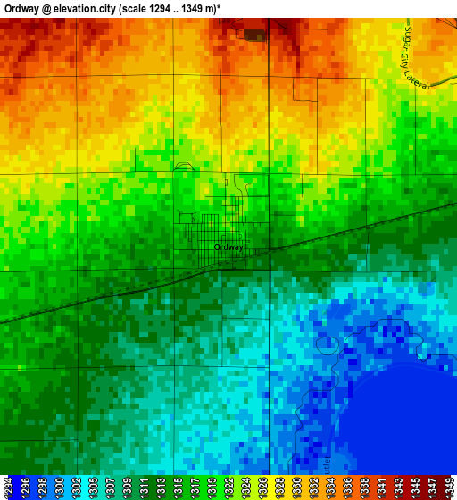
Below is the Elevation map of Ordway, which displays elevation range with different colors. Scale of the first map is from 1294 to 1349 m (4245 to 4426 ft) with average elevation of 1316.7 meters (=4320 ft) [note 1]
These maps also provides idea of topography and contour of this city, they are displayed at different zoom levels. More info about maps, scale and edge coordinates you can find below images.
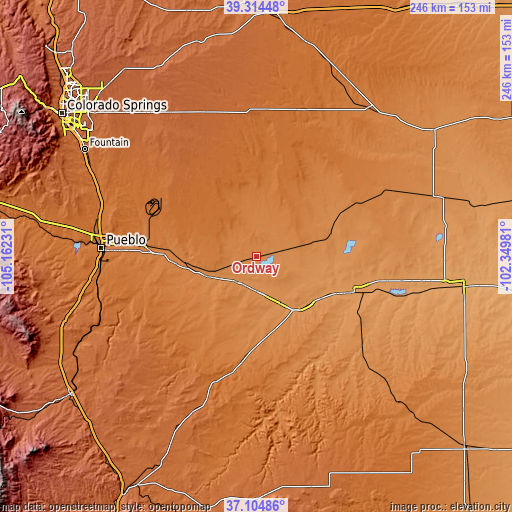
| \ | Map #1 | Topo.Map |
| Scale [m] | 1294..1349 m | × |
| Scale [ft] | 4245..4426 ft | × |
| Average | 1316.7 m = 4320 ft | × |
| Width | 7.68 km = 4.8 mi | 245.7 km = 152.7 mi |
| Height | 7.68 km = 4.8 mi | 245.7 km = 152.7 mi |
| ↑Max Latitude | 38.252578° | 39.31448° |
| Latitude at center | 38.21806° | 38.21806° |
| ↓Min Latitude | 38.183526° | 37.10486° |
| ← Min Longitude | -103.800005° | -105.16231° |
| Longitude center | -103.75606° | -103.75606° |
| →Max Longitude | -103.712115° | -102.34981° |
Nearby cities:
Cities around Ordway sort by population:
• Pueblo elevation 1430 m
74.6 km,  273°
273°
• Security-Widefield 1783 m
102.1 km,  305°
305°
• Pueblo West 1548 m
85.6 km,  279°
279°
• Fountain 1694 m
97.1 km,  302°
302°
• Lamar 1107 m
100.3 km,  98°
98°
• La Junta 1245 m
31.9 km,  144°
144°
• Rocky Ford 1276 m
18.7 km,  170°
170°
• Las Animas 1192 m
49.6 km,  109°
109°
• Colorado City 1788 m
99.2 km,  252°
252°
• Fowler 1328 m
25.4 km, 247°
• Ellicott 1838 m
88.1 km,  321°
321°
• Eads 1289 m
89.8 km,  71°
71°
Multilingual:
 En español:
Ordway elevación 1317 m.
 En France:
Ordway élévation 1317 m.


Sources and notes:
- [note 1] Map square and city borders are not equal. Map elevation data is calculated only from area inside that square.
- [src 1] Elevation data from geonames database provided with same terms of usage.
- [src 2] The elevation map of Ordway is generated using elevation data from NASA's 3 arcsec (90m) resolution SRTM data.
- [src 3] Base (background) map © OpenStreetMap contributors tiles are generated by Geofabrik and OpenTopoMap.
Copyright & License:
This Ordway Elevation Map is licensed under CC BY-SA. You may reuse any part from this page, if you give a proper credit by linking to this URL:
 More info on terms of use page.