Richland Center elevation
Richland Center (Wisconsin, Richland County), United States elevation is 227 meters and Richland Center elevation in feet is 745 ft above sea level [src 1]. Richland Center is a seat of a second-order administrative division (feature code) with elevation that is 52 meters (171 ft) smaller than average city elevation in United States.
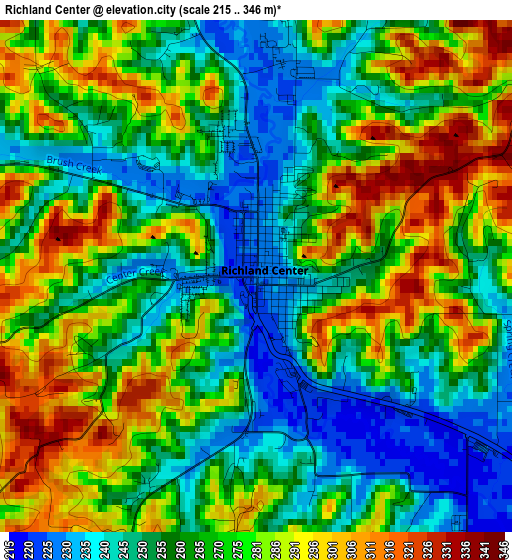
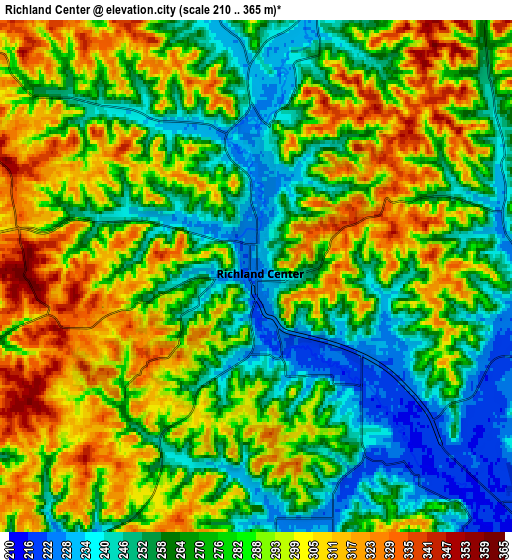
Below is the Elevation map of Richland Center, which displays elevation range with different colors. Scale of the first map is from 215 to 346 m (705 to 1135 ft) with average elevation of 269 meters (=883 ft) [note 1]
These maps also provides idea of topography and contour of this city, they are displayed at different zoom levels. More info about maps, scale and edge coordinates you can find below images.
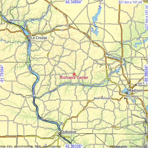
| \ | Map #1 | Map #2 | Topo.Map |
| Scale [m] | 215..346 m | 210..365 m | × |
| Scale [ft] | 705..1135 ft | 689..1198 ft | × |
| Average | 269 m = 883 ft | 279.4 m = 917 ft | × |
| Width | 7.11 km = 4.4 mi | 14.22 km = 8.8 mi | 227.5 km = 141.4 mi |
| Height | 7.11 km = 4.4 mi | 14.22 km = 8.8 mi | 227.4 km = 141.3 mi |
| ↑Max Latitude | 43.366666° | 43.398604° | 44.34894° |
| Latitude at center | 43.33471° | 43.33471° | 43.33471° |
| ↓Min Latitude | 43.302738° | 43.270748° | 42.30326° |
| ← Min Longitude | -90.430735° | -90.474681° | -91.79304° |
| Longitude center | -90.38679° | -90.38679° | -90.38679° |
| →Max Longitude | -90.342845° | -90.298899° | -88.98054° |
Nearby cities:
Cities around Richland Center sort by population:
• Reedsburg elevation 277 m
38 km,  54°
54°
• Dodgeville 369 m
46.6 km,  153°
153°
• Viroqua 387 m
47.5 km,  301°
301°
• Boscobel 207 m
34.1 km,  229°
229°
• Fennimore 365 m
44.7 km,  209°
209°
• Westby 398 m
52 km,  313°
313°
• Mazomanie 236 m
51.1 km,  110°
110°
• Spring Green 223 m
31.3 km,  124°
124°
• West Baraboo 271 m
52.2 km,  72°
72°
• Hillsboro 305 m
35.5 km,  5°
5°
• Elroy 301 m
46.1 km, 11°
• Muscoda 211 m
17.3 km,  195°
195°
Multilingual:
 En español:
Richland Center elevación 227 m.
 En France:
Richland Center élévation 227 m.
 Auf Deutsch:
Richland Center höhe über dem Meeresspiegel ist 227 m.

Sources and notes:
- [note 1] Map square and city borders are not equal. Map elevation data is calculated only from area inside that square.
- [src 1] Elevation data from geonames database provided with same terms of usage.
- [src 2] The elevation map of Richland Center is generated using elevation data from NASA's 3 arcsec (90m) resolution SRTM data.
- [src 3] Base (background) map © OpenStreetMap contributors tiles are generated by Geofabrik and OpenTopoMap.
Copyright & License:
This Richland Center Elevation Map is licensed under CC BY-SA. You may reuse any part from this page, if you give a proper credit by linking to this URL:
 More info on terms of use page.