Dodgeville elevation
Dodgeville (Wisconsin, Iowa County), United States elevation is 369 meters and Dodgeville elevation in feet is 1211 ft above sea level [src 1]. Dodgeville is a seat of a second-order administrative division (feature code) with elevation that is 90 meters (295 ft) bigger than average city elevation in United States.
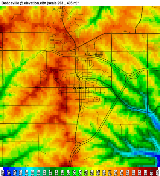
Below is the Elevation map of Dodgeville, which displays elevation range with different colors. Scale of the first map is from 293 to 405 m (961 to 1329 ft) with average elevation of 362.1 meters (=1188 ft) [note 1]
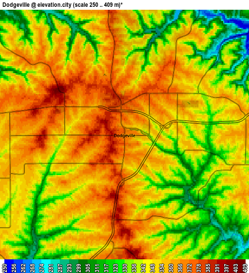
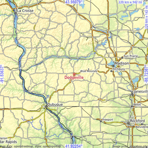
These maps also provides idea of topography and contour of this city, they are displayed at different zoom levels. More info about maps, scale and edge coordinates you can find below images.
| \ | Map #1 | Map #2 | Topo.Map |
| Scale [m] | 293..405 m | 250..409 m | × |
| Scale [ft] | 961..1329 ft | 820..1342 ft | × |
| Average | 362.1 m = 1188 ft | 346.7 m = 1137 ft | × |
| Width | 7.15 km = 4.4 mi | 14.3 km = 8.9 mi | 228.9 km = 142.2 mi |
| Height | 7.15 km = 4.4 mi | 14.3 km = 8.9 mi | 228.8 km = 142.2 mi |
| ↑Max Latitude | 42.992422° | 43.024557° | 43.98079° |
| Latitude at center | 42.96027° | 42.96027° | 42.96027° |
| ↓Min Latitude | 42.928101° | 42.895916° | 41.92254° |
| ← Min Longitude | -90.174065° | -90.218011° | -91.53637° |
| Longitude center | -90.13012° | -90.13012° | -90.13012° |
| →Max Longitude | -90.086175° | -90.042229° | -88.72387° |
Nearby cities:
Cities around Dodgeville sort by population:
• Platteville elevation 300 m
37.9 km,  228°
228°
• Mount Horeb 381 m
32.3 km,  80°
80°
• Cross Plains 265 m
42.2 km,  66°
66°
• Mineral Point 318 m
11.9 km,  199°
199°
• Fennimore 365 m
42.8 km,  273°
273°
• Darlington 264 m
30.8 km,  178°
178°
• New Glarus 278 m
43.5 km,  111°
111°
• Mazomanie 236 m
36.3 km,  48°
48°
• Spring Green 223 m
24.4 km,  11°
11°
• Black Earth 252 m
36.8 km,  57°
57°
• Muscoda 211 m
35.6 km,  314°
314°
• Barneveld 377 m
20.1 km, 72°
Multilingual:
 En español:
Dodgeville elevación 369 m.
 En France:
Dodgeville élévation 369 m.
 Auf Deutsch:
Dodgeville höhe über dem Meeresspiegel ist 369 m.

Sources and notes:
- [note 1] Map square and city borders are not equal. Map elevation data is calculated only from area inside that square.
- [src 1] Elevation data from geonames database provided with same terms of usage.
- [src 2] The elevation map of Dodgeville is generated using elevation data from NASA's 3 arcsec (90m) resolution SRTM data.
- [src 3] Base (background) map © OpenStreetMap contributors tiles are generated by Geofabrik and OpenTopoMap.
Copyright & License:
This Dodgeville Elevation Map is licensed under CC BY-SA. You may reuse any part from this page, if you give a proper credit by linking to this URL:
 More info on terms of use page.