Mount Horeb elevation
Mount Horeb (Wisconsin, Dane County), United States elevation is 381 meters and Mount Horeb elevation in feet is 1250 ft above sea level [src 1]. Mount Horeb is a populated place (feature code) with elevation that is 102 meters (335 ft) bigger than average city elevation in United States.
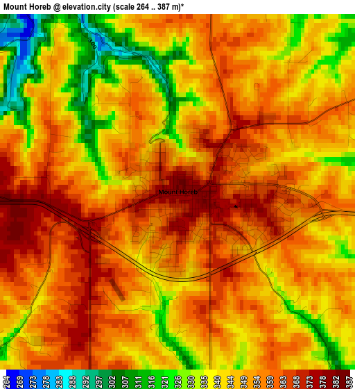
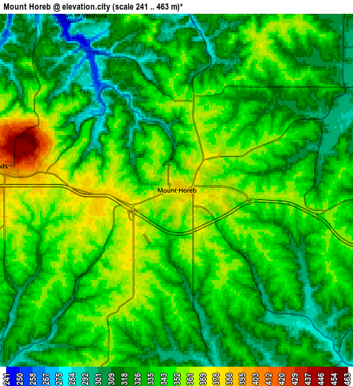
Below is the Elevation map of Mount Horeb, which displays elevation range with different colors. Scale of the first map is from 264 to 387 m (866 to 1270 ft) with average elevation of 348.8 meters (=1144 ft) [note 1]
These maps also provides idea of topography and contour of this city, they are displayed at different zoom levels. More info about maps, scale and edge coordinates you can find below images.
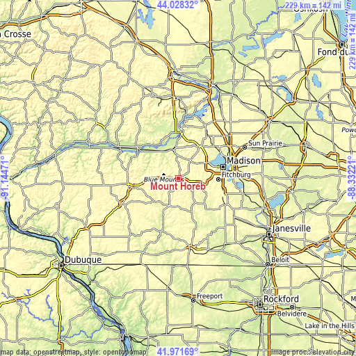
| \ | Map #1 | Map #2 | Topo.Map |
| Scale [m] | 264..387 m | 241..463 m | × |
| Scale [ft] | 866..1270 ft | 791..1519 ft | × |
| Average | 348.8 m = 1144 ft | 335 m = 1099 ft | × |
| Width | 7.15 km = 4.4 mi | 14.29 km = 8.9 mi | 228.7 km = 142.1 mi |
| Height | 7.15 km = 4.4 mi | 14.29 km = 8.9 mi | 228.7 km = 142.1 mi |
| ↑Max Latitude | 43.040737° | 43.072846° | 44.02832° |
| Latitude at center | 43.00861° | 43.00861° | 43.00861° |
| ↓Min Latitude | 42.976467° | 42.944306° | 41.97169° |
| ← Min Longitude | -89.782405° | -89.826351° | -91.14471° |
| Longitude center | -89.73846° | -89.73846° | -89.73846° |
| →Max Longitude | -89.694515° | -89.650569° | -88.33221° |
Nearby cities:
Cities around Mount Horeb sort by population:
• Madison elevation 272 m
28.3 km,  75°
75°
• Fitchburg 310 m
22.5 km,  103°
103°
• Middleton 291 m
21.4 km,  62°
62°
• Verona 298 m
16.8 km, 96°
• Cross Plains 265 m
13.6 km,  29°
29°
• Belleville 267 m
23.2 km,  135°
135°
• New Glarus 278 m
23.2 km,  158°
158°
• Shorewood Hills 277 m
25 km,  72°
72°
• Roxbury 264 m
27.3 km,  10°
10°
• Mazomanie 236 m
19.2 km,  346°
346°
• Black Earth 252 m
14.3 km,  357°
357°
• Barneveld 377 m
12.8 km,  273°
273°
Multilingual:
 En español:
Mount Horeb elevación 381 m.
 En France:
Mount Horeb élévation 381 m.
 Auf Deutsch:
Mount Horeb höhe über dem Meeresspiegel ist 381 m.

Sources and notes:
- [note 1] Map square and city borders are not equal. Map elevation data is calculated only from area inside that square.
- [src 1] Elevation data from geonames database provided with same terms of usage.
- [src 2] The elevation map of Mount Horeb is generated using elevation data from NASA's 3 arcsec (90m) resolution SRTM data.
- [src 3] Base (background) map © OpenStreetMap contributors tiles are generated by Geofabrik and OpenTopoMap.
Copyright & License:
This Mount Horeb Elevation Map is licensed under CC BY-SA. You may reuse any part from this page, if you give a proper credit by linking to this URL:
 More info on terms of use page.