Amherst elevation
Amherst (Wisconsin, Portage County), United States elevation is 321 meters and Amherst elevation in feet is 1053 ft above sea level [src 1]. Amherst is a populated place (feature code) with elevation that is 42 meters (138 ft) bigger than average city elevation in United States.
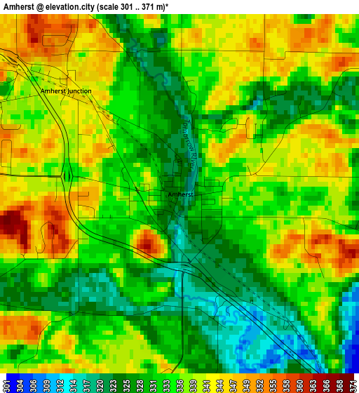
Below is the Elevation map of Amherst, which displays elevation range with different colors. Scale of the first map is from 301 to 371 m (988 to 1217 ft) with average elevation of 334.9 meters (=1099 ft) [note 1]
These maps also provides idea of topography and contour of this city, they are displayed at different zoom levels. More info about maps, scale and edge coordinates you can find below images.
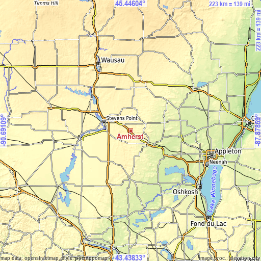
| \ | Map #1 | Topo.Map |
| Scale [m] | 301..371 m | × |
| Scale [ft] | 988..1217 ft | × |
| Average | 334.9 m = 1099 ft | × |
| Width | 6.98 km = 4.3 mi | 223.2 km = 138.7 mi |
| Height | 6.98 km = 4.3 mi | 223.2 km = 138.7 mi |
| ↑Max Latitude | 44.482172° | 45.44604° |
| Latitude at center | 44.45081° | 44.45081° |
| ↓Min Latitude | 44.419431° | 43.43833° |
| ← Min Longitude | -89.328785° | -90.69109° |
| Longitude center | -89.28484° | -89.28484° |
| →Max Longitude | -89.240895° | -87.87859° |
Nearby cities:
Cities around Amherst sort by population:
• Stevens Point elevation 334 m
24.4 km,  289°
289°
• Plover 329 m
20.6 km,  271°
271°
• Waupaca 259 m
18.9 km,  123°
123°
• Lake Wazeecha 318 m
38.5 km,  256°
256°
• Weyauwega 244 m
31.4 km, 117°
• King 276 m
17 km,  137°
137°
• Whiting 332 m
22.2 km,  282°
282°
• Manawa 251 m
29 km,  87°
87°
• Iola 291 m
13.8 km,  62°
62°
• Marion 262 m
39.8 km,  52°
52°
• Bevent 374 m
36.5 km,  346°
346°
• Mount Morris 274 m
38.1 km,  168°
168°
Multilingual:
 En español:
Amherst elevación 321 m.
 En France:
Amherst élévation 321 m.


Sources and notes:
- [note 1] Map square and city borders are not equal. Map elevation data is calculated only from area inside that square.
- [src 1] Elevation data from geonames database provided with same terms of usage.
- [src 2] The elevation map of Amherst is generated using elevation data from NASA's 3 arcsec (90m) resolution SRTM data.
- [src 3] Base (background) map © OpenStreetMap contributors tiles are generated by Geofabrik and OpenTopoMap.
Copyright & License:
This Amherst Elevation Map is licensed under CC BY-SA. You may reuse any part from this page, if you give a proper credit by linking to this URL:
 More info on terms of use page.