Marion elevation
Marion (Wisconsin, Waupaca County), United States elevation is 262 meters and Marion elevation in feet is 860 ft above sea level [src 1]. Marion is a populated place (feature code) with elevation that is 17 meters (56 ft) smaller than average city elevation in United States.
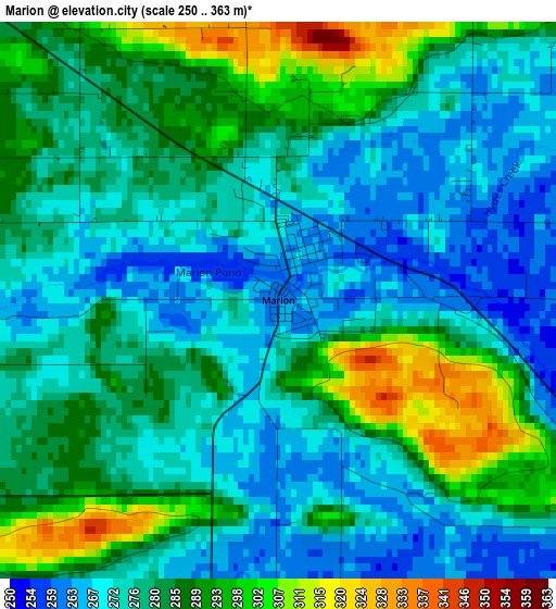
Below is the Elevation map of Marion, which displays elevation range with different colors. Scale of the first map is from 250 to 363 m (820 to 1191 ft) with average elevation of 280.3 meters (=920 ft) [note 1]
These maps also provides idea of topography and contour of this city, they are displayed at different zoom levels. More info about maps, scale and edge coordinates you can find below images.
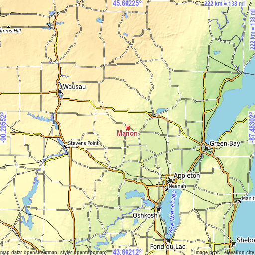
| \ | Map #1 | Topo.Map |
| Scale [m] | 250..363 m | × |
| Scale [ft] | 820..1191 ft | × |
| Average | 280.3 m = 920 ft | × |
| Width | 6.95 km = 4.3 mi | 222.4 km = 138.2 mi |
| Height | 6.95 km = 4.3 mi | 222.4 km = 138.2 mi |
| ↑Max Latitude | 44.702054° | 45.66225° |
| Latitude at center | 44.67081° | 44.67081° |
| ↓Min Latitude | 44.63955° | 43.66212° |
| ← Min Longitude | -88.933215° | -90.29552° |
| Longitude center | -88.88927° | -88.88927° |
| →Max Longitude | -88.845325° | -87.48302° |
Nearby cities:
Cities around Marion sort by population:
• Shawano elevation 248 m
25.4 km,  60°
60°
• New London 235 m
33.1 km,  159°
159°
• Waupaca 259 m
38.1 km,  204°
204°
• Clintonville 252 m
11.5 km,  119°
119°
• Weyauwega 244 m
39 km,  185°
185°
• Belle Plaine 261 m
18.3 km,  74°
74°
• Legend Lake 254 m
36.6 km,  48°
48°
• Bonduel 271 m
36 km,  77°
77°
• Manawa 251 m
23.1 km, 186°
• Iola 291 m
26.3 km,  226°
226°
• Keshena 256 m
31.1 km,  40°
40°
• Wittenberg 360 m
28.1 km,  308°
308°
Multilingual:
 En español:
Marion elevación 262 m.
 En France:
Marion élévation 262 m.


Sources and notes:
- [note 1] Map square and city borders are not equal. Map elevation data is calculated only from area inside that square.
- [src 1] Elevation data from geonames database provided with same terms of usage.
- [src 2] The elevation map of Marion is generated using elevation data from NASA's 3 arcsec (90m) resolution SRTM data.
- [src 3] Base (background) map © OpenStreetMap contributors tiles are generated by Geofabrik and OpenTopoMap.
Copyright & License:
This Marion Elevation Map is licensed under CC BY-SA. You may reuse any part from this page, if you give a proper credit by linking to this URL:
 More info on terms of use page.