Wittenberg elevation
Wittenberg (Wisconsin, Shawano County), United States elevation is 360 meters and Wittenberg elevation in feet is 1181 ft above sea level [src 1]. Wittenberg is a populated place (feature code) with elevation that is 81 meters (266 ft) bigger than average city elevation in United States.
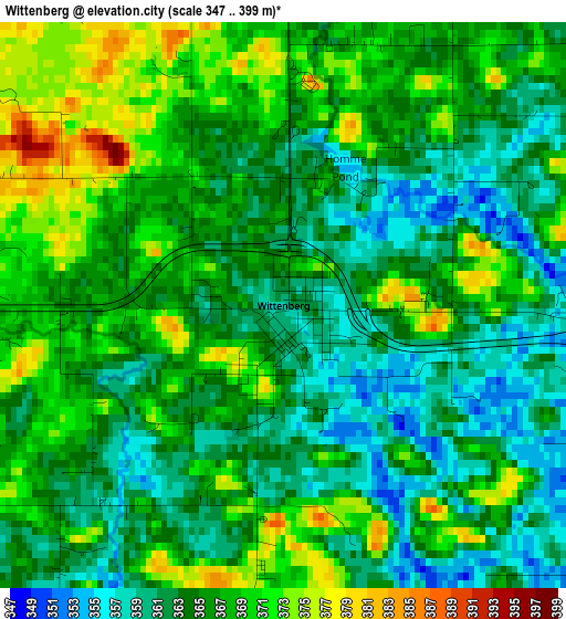
Below is the Elevation map of Wittenberg, which displays elevation range with different colors. Scale of the first map is from 347 to 399 m (1138 to 1309 ft) with average elevation of 365.1 meters (=1198 ft) [note 1]
These maps also provides idea of topography and contour of this city, they are displayed at different zoom levels. More info about maps, scale and edge coordinates you can find below images.
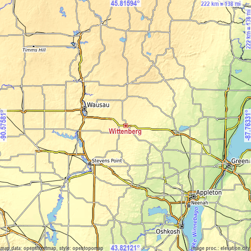
| \ | Map #1 | Topo.Map |
| Scale [m] | 347..399 m | × |
| Scale [ft] | 1138..1309 ft | × |
| Average | 365.1 m = 1198 ft | × |
| Width | 6.93 km = 4.3 mi | 221.8 km = 137.8 mi |
| Height | 6.93 km = 4.3 mi | 221.8 km = 137.8 mi |
| ↑Max Latitude | 44.858359° | 45.81594° |
| Latitude at center | 44.8272° | 44.8272° |
| ↓Min Latitude | 44.796024° | 43.82121° |
| ← Min Longitude | -89.213505° | -90.57581° |
| Longitude center | -89.16956° | -89.16956° |
| →Max Longitude | -89.125615° | -87.76331° |
Nearby cities:
Cities around Wittenberg sort by population:
• Wausau elevation 371 m
39.1 km,  292°
292°
• Weston 393 m
30.6 km,  283°
283°
• Antigo 459 m
34.8 km,  2°
2°
• Kronenwetter 370 m
33.2 km,  269°
269°
• Rib Mountain 404 m
41 km, 283°
• Rothschild 370 m
36.1 km, 280°
• Clintonville 252 m
39.5 km,  125°
125°
• Evergreen 361 m
36.9 km, 272°
• Schofield 367 m
35.5 km, 284°
• Iola 291 m
35.6 km,  175°
175°
• Marion 262 m
28.1 km, 128°
• Bevent 374 m
18.5 km,  250°
250°
Multilingual:
 En español:
Wittenberg elevación 360 m.
 En France:
Wittenberg élévation 360 m.
 Auf Deutsch:
Wittenberg höhe über dem Meeresspiegel ist 360 m.

Sources and notes:
- [note 1] Map square and city borders are not equal. Map elevation data is calculated only from area inside that square.
- [src 1] Elevation data from geonames database provided with same terms of usage.
- [src 2] The elevation map of Wittenberg is generated using elevation data from NASA's 3 arcsec (90m) resolution SRTM data.
- [src 3] Base (background) map © OpenStreetMap contributors tiles are generated by Geofabrik and OpenTopoMap.
Copyright & License:
This Wittenberg Elevation Map is licensed under CC BY-SA. You may reuse any part from this page, if you give a proper credit by linking to this URL:
 More info on terms of use page.