Stevens Point elevation
Stevens Point (Wisconsin, Portage County), United States elevation is 334 meters and Stevens Point elevation in feet is 1096 ft above sea level [src 1]. Stevens Point is a seat of a second-order administrative division (feature code) with elevation that is 55 meters (180 ft) bigger than average city elevation in United States.
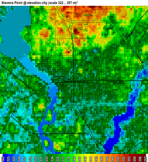
Below is the Elevation map of Stevens Point, which displays elevation range with different colors. Scale of the first map is from 322 to 357 m (1056 to 1171 ft) with average elevation of 334.4 meters (=1097 ft) [note 1]
These maps also provides idea of topography and contour of this city, they are displayed at different zoom levels. More info about maps, scale and edge coordinates you can find below images.
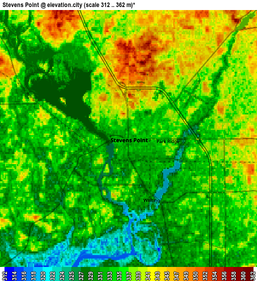
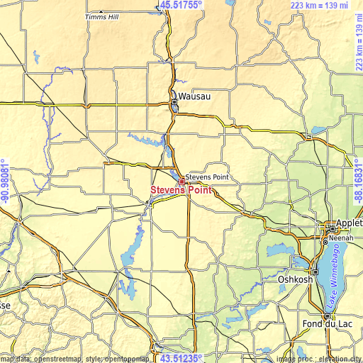
| \ | Map #1 | Map #2 | Topo.Map |
| Scale [m] | 322..357 m | 312..362 m | × |
| Scale [ft] | 1056..1171 ft | 1024..1188 ft | × |
| Average | 334.4 m = 1097 ft | 335.2 m = 1100 ft | × |
| Width | 6.97 km = 4.3 mi | 13.93 km = 8.7 mi | 223 km = 138.6 mi |
| Height | 6.97 km = 4.3 mi | 13.93 km = 8.7 mi | 222.9 km = 138.5 mi |
| ↑Max Latitude | 44.554903° | 44.586209° | 45.51755° |
| Latitude at center | 44.52358° | 44.52358° | 44.52358° |
| ↓Min Latitude | 44.49224° | 44.460884° | 43.51235° |
| ← Min Longitude | -89.618505° | -89.662451° | -90.98081° |
| Longitude center | -89.57456° | -89.57456° | -89.57456° |
| →Max Longitude | -89.530615° | -89.486669° | -88.16831° |
Nearby cities:
Cities around Stevens Point sort by population:
• Wisconsin Rapids elevation 314 m
24.8 km,  231°
231°
• Plover 329 m
7.9 km,  162°
162°
• Kronenwetter 370 m
33.2 km,  357°
357°
• Mosinee 355 m
31.6 km,  341°
341°
• Evergreen 361 m
35.8 km,  351°
351°
• Lake Wazeecha 318 m
22.3 km,  220°
220°
• Nekoosa 292 m
35.2 km, 228°
• Port Edwards 298 m
30 km, 230°
• Whiting 332 m
3.6 km, 159°
• Iola 291 m
35.2 km,  92°
92°
• Bevent 374 m
31.1 km,  28°
28°
• Amherst 321 m
24.4 km,  109°
109°
Multilingual:
 En español:
Stevens Point elevación 334 m.
 En France:
Stevens Point élévation 334 m.
 Auf Deutsch:
Stevens Point höhe über dem Meeresspiegel ist 334 m.

Sources and notes:
- [note 1] Map square and city borders are not equal. Map elevation data is calculated only from area inside that square.
- [src 1] Elevation data from geonames database provided with same terms of usage.
- [src 2] The elevation map of Stevens Point is generated using elevation data from NASA's 3 arcsec (90m) resolution SRTM data.
- [src 3] Base (background) map © OpenStreetMap contributors tiles are generated by Geofabrik and OpenTopoMap.
Copyright & License:
This Stevens Point Elevation Map is licensed under CC BY-SA. You may reuse any part from this page, if you give a proper credit by linking to this URL:
 More info on terms of use page.