South Barre elevation
South Barre (Vermont, Washington County), United States elevation is 226 meters and South Barre elevation in feet is 741 ft above sea level [src 1]. South Barre is a populated place (feature code) with elevation that is 53 meters (174 ft) smaller than average city elevation in United States.
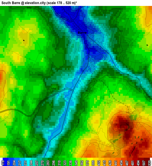
Below is the Elevation map of South Barre, which displays elevation range with different colors. Scale of the first map is from 178 to 520 m (584 to 1706 ft) with average elevation of 319.6 meters (=1049 ft) [note 1]
These maps also provides idea of topography and contour of this city, they are displayed at different zoom levels. More info about maps, scale and edge coordinates you can find below images.
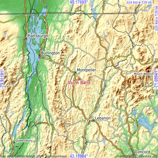
| \ | Map #1 | Topo.Map |
| Scale [m] | 178..520 m | × |
| Scale [ft] | 584..1706 ft | × |
| Average | 319.6 m = 1049 ft | × |
| Width | 7.01 km = 4.4 mi | 224.3 km = 139.4 mi |
| Height | 7.01 km = 4.4 mi | 224.3 km = 139.4 mi |
| ↑Max Latitude | 44.208519° | 45.17693° |
| Latitude at center | 44.17701° | 44.17701° |
| ↓Min Latitude | 44.145484° | 43.15984° |
| ← Min Longitude | -72.549605° | -73.91191° |
| Longitude center | -72.50566° | -72.50566° |
| →Max Longitude | -72.461715° | -71.09941° |
Nearby cities:
Cities around South Barre sort by population:
• Barre elevation 187 m
2.2 km,  7°
7°
• Montpelier 163 m
10.8 km,  328°
328°
• Stowe 222 m
35.1 km,  336°
336°
• Northfield 224 m
12.4 km,  256°
256°
• Randolph 213 m
30.8 km,  204°
204°
• Waterbury 135 m
26.8 km,  311°
311°
• Moretown 191 m
21.9 km,  291°
291°
• Hardwick 252 m
38 km,  16°
16°
• Chelsea 254 m
21.3 km,  167°
167°
• Williamstown 272 m
6.8 km, 204°
• Woodsville 138 m
37.5 km,  94°
94°
• Washington 390 m
9.8 km,  143°
143°
Multilingual:
 En español:
South Barre elevación 226 m.
 En France:
South Barre élévation 226 m.
 Auf Deutsch:
South Barre höhe über dem Meeresspiegel ist 226 m.

Sources and notes:
- [note 1] Map square and city borders are not equal. Map elevation data is calculated only from area inside that square.
- [src 1] Elevation data from geonames database provided with same terms of usage.
- [src 2] The elevation map of South Barre is generated using elevation data from NASA's 3 arcsec (90m) resolution SRTM data.
- [src 3] Base (background) map © OpenStreetMap contributors tiles are generated by Geofabrik and OpenTopoMap.
Copyright & License:
This South Barre Elevation Map is licensed under CC BY-SA. You may reuse any part from this page, if you give a proper credit by linking to this URL:
 More info on terms of use page.