Northfield elevation
Northfield (Vermont, Washington County), United States elevation is 224 meters and Northfield elevation in feet is 735 ft above sea level [src 1]. Northfield is a populated place (feature code) with elevation that is 55 meters (180 ft) smaller than average city elevation in United States.
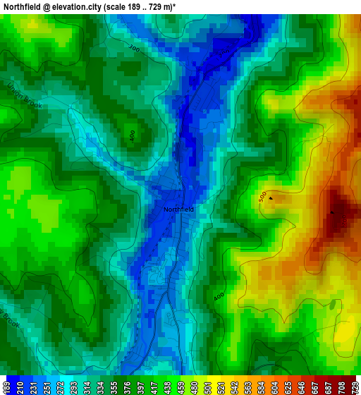
Below is the Elevation map of Northfield, which displays elevation range with different colors. Scale of the first map is from 189 to 729 m (620 to 2392 ft) with average elevation of 379.4 meters (=1245 ft) [note 1]
These maps also provides idea of topography and contour of this city, they are displayed at different zoom levels. More info about maps, scale and edge coordinates you can find below images.
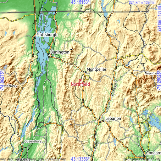
| \ | Map #1 | Topo.Map |
| Scale [m] | 189..729 m | × |
| Scale [ft] | 620..2392 ft | × |
| Average | 379.4 m = 1245 ft | × |
| Width | 7.01 km = 4.4 mi | 224.4 km = 139.4 mi |
| Height | 7.01 km = 4.4 mi | 224.4 km = 139.4 mi |
| ↑Max Latitude | 44.182693° | 45.15153° |
| Latitude at center | 44.15117° | 44.15117° |
| ↓Min Latitude | 44.119631° | 43.13356° |
| ← Min Longitude | -72.700445° | -74.06275° |
| Longitude center | -72.6565° | -72.6565° |
| →Max Longitude | -72.612555° | -71.25025° |
Nearby cities:
Cities around Northfield sort by population:
• Barre elevation 187 m
13.3 km,  67°
67°
• Montpelier 163 m
13.7 km,  28°
28°
• Bristol 175 m
33.8 km,  266°
266°
• Randolph 213 m
25.2 km,  181°
181°
• Waterbury 135 m
22.2 km,  339°
339°
• Starksboro 188 m
33.1 km,  284°
284°
• Moretown 191 m
13.9 km,  323°
323°
• Lincoln 300 m
27.6 km,  259°
259°
• Chelsea 254 m
24.5 km,  137°
137°
• South Barre 226 m
12.4 km,  76°
76°
• Williamstown 272 m
9.7 km,  109°
109°
• Washington 390 m
18.6 km, 105°
Multilingual:
 En español:
Northfield elevación 224 m.
 En France:
Northfield élévation 224 m.
 Auf Deutsch:
Northfield höhe über dem Meeresspiegel ist 224 m.

Sources and notes:
- [note 1] Map square and city borders are not equal. Map elevation data is calculated only from area inside that square.
- [src 1] Elevation data from geonames database provided with same terms of usage.
- [src 2] The elevation map of Northfield is generated using elevation data from NASA's 3 arcsec (90m) resolution SRTM data.
- [src 3] Base (background) map © OpenStreetMap contributors tiles are generated by Geofabrik and OpenTopoMap.
Copyright & License:
This Northfield Elevation Map is licensed under CC BY-SA. You may reuse any part from this page, if you give a proper credit by linking to this URL:
 More info on terms of use page.