Randolph elevation
Randolph (Vermont, Orange County), United States elevation is 213 meters and Randolph elevation in feet is 699 ft above sea level [src 1]. Randolph is a populated place (feature code) with elevation that is 66 meters (217 ft) smaller than average city elevation in United States.
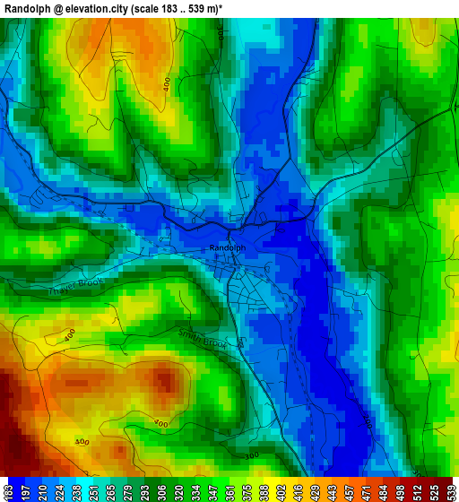
Below is the Elevation map of Randolph, which displays elevation range with different colors. Scale of the first map is from 183 to 539 m (600 to 1768 ft) with average elevation of 307.5 meters (=1009 ft) [note 1]
These maps also provides idea of topography and contour of this city, they are displayed at different zoom levels. More info about maps, scale and edge coordinates you can find below images.
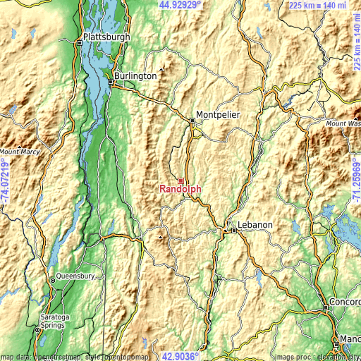
| \ | Map #1 | Topo.Map |
| Scale [m] | 183..539 m | × |
| Scale [ft] | 600..1768 ft | × |
| Average | 307.5 m = 1009 ft | × |
| Width | 7.04 km = 4.4 mi | 225.2 km = 139.9 mi |
| Height | 7.04 km = 4.4 mi | 225.2 km = 139.9 mi |
| ↑Max Latitude | 43.956713° | 44.92929° |
| Latitude at center | 43.92507° | 43.92507° |
| ↓Min Latitude | 43.89341° | 42.9036° |
| ← Min Longitude | -72.709885° | -74.07219° |
| Longitude center | -72.66594° | -72.66594° |
| →Max Longitude | -72.621995° | -71.25969° |
Nearby cities:
Cities around Randolph sort by population:
• Barre elevation 187 m
33 km,  23°
23°
• Northfield 224 m
25.2 km,  1°
1°
• Brandon 135 m
36.6 km,  247°
247°
• Lincoln 300 m
33.2 km,  307°
307°
• Chelsea 254 m
18.9 km,  67°
67°
• Chittenden 348 m
33.1 km,  223°
223°
• South Barre 226 m
30.8 km, 24°
• Williamstown 272 m
24 km, 24°
• Salisbury 134 m
34.9 km,  264°
264°
• Leicester 137 m
36 km, 259°
• Washington 390 m
27.4 km,  42°
42°
• Woodstock 217 m
35.5 km,  160°
160°
Multilingual:
 En español:
Randolph elevación 213 m.
 En France:
Randolph élévation 213 m.
 Auf Deutsch:
Randolph höhe über dem Meeresspiegel ist 213 m.

Sources and notes:
- [note 1] Map square and city borders are not equal. Map elevation data is calculated only from area inside that square.
- [src 1] Elevation data from geonames database provided with same terms of usage.
- [src 2] The elevation map of Randolph is generated using elevation data from NASA's 3 arcsec (90m) resolution SRTM data.
- [src 3] Base (background) map © OpenStreetMap contributors tiles are generated by Geofabrik and OpenTopoMap.
Copyright & License:
This Randolph Elevation Map is licensed under CC BY-SA. You may reuse any part from this page, if you give a proper credit by linking to this URL:
 More info on terms of use page.