Leicester elevation
Leicester (Vermont, Addison County), United States elevation is 137 meters and Leicester elevation in feet is 449 ft above sea level [src 1]. Leicester is a populated place (feature code) with elevation that is 142 meters (466 ft) smaller than average city elevation in United States.
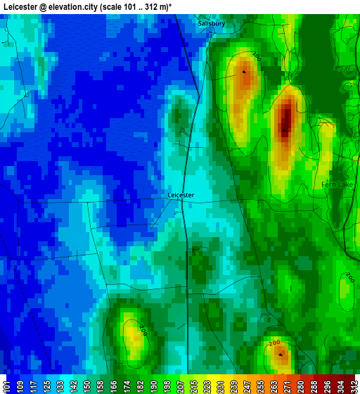
Below is the Elevation map of Leicester, which displays elevation range with different colors. Scale of the first map is from 101 to 312 m (331 to 1024 ft) with average elevation of 152 meters (=499 ft) [note 1]
These maps also provides idea of topography and contour of this city, they are displayed at different zoom levels. More info about maps, scale and edge coordinates you can find below images.
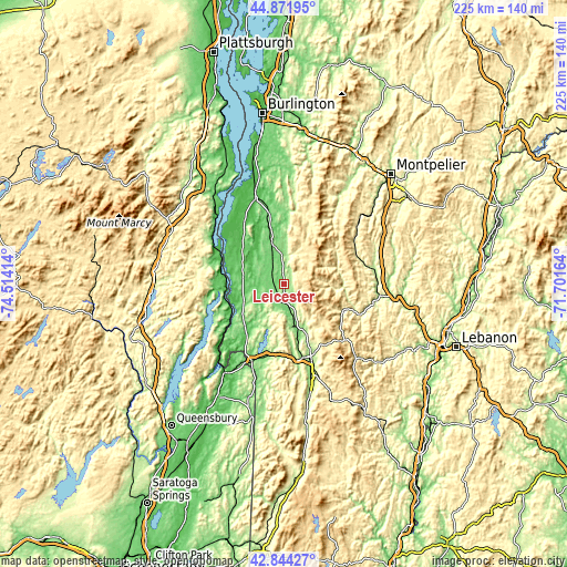
| \ | Map #1 | Topo.Map |
| Scale [m] | 101..312 m | × |
| Scale [ft] | 331..1024 ft | × |
| Average | 152 m = 499 ft | × |
| Width | 7.05 km = 4.4 mi | 225.5 km = 140.1 mi |
| Height | 7.05 km = 4.4 mi | 225.4 km = 140.1 mi |
| ↑Max Latitude | 43.898404° | 44.87195° |
| Latitude at center | 43.86673° | 43.86673° |
| ↓Min Latitude | 43.835039° | 42.84427° |
| ← Min Longitude | -73.151835° | -74.51414° |
| Longitude center | -73.10789° | -73.10789° |
| →Max Longitude | -73.063945° | -71.70164° |
Nearby cities:
Cities around Leicester sort by population:
• Rutland elevation 200 m
30.5 km,  159°
159°
• Middlebury (village) 111 m
17.3 km,  343°
343°
• Ticonderoga 51 m
25.4 km,  265°
265°
• Bristol 175 m
29.7 km,  4°
4°
• Brandon 135 m
7.8 km,  167°
167°
• Castleton 139 m
29.1 km,  191°
191°
• Addison 89 m
29.2 km,  327°
327°
• Lincoln 300 m
28 km,  18°
18°
• Chittenden 348 m
21.8 km,  144°
144°
• Bridport 90 m
21 km,  308°
308°
• Salisbury 134 m
3.4 km,  11°
11°
• Mendon 317 m
27.9 km,  148°
148°
Multilingual:
 En español:
Leicester elevación 137 m.
 En France:
Leicester élévation 137 m.
 Auf Deutsch:
Leicester höhe über dem Meeresspiegel ist 137 m.

Sources and notes:
- [note 1] Map square and city borders are not equal. Map elevation data is calculated only from area inside that square.
- [src 1] Elevation data from geonames database provided with same terms of usage.
- [src 2] The elevation map of Leicester is generated using elevation data from NASA's 3 arcsec (90m) resolution SRTM data.
- [src 3] Base (background) map © OpenStreetMap contributors tiles are generated by Geofabrik and OpenTopoMap.
Copyright & License:
This Leicester Elevation Map is licensed under CC BY-SA. You may reuse any part from this page, if you give a proper credit by linking to this URL:
 More info on terms of use page.