Rutland elevation
Rutland (Vermont, Rutland County), United States elevation is 200 meters and Rutland elevation in feet is 656 ft above sea level [src 1]. Rutland is a seat of a second-order administrative division (feature code) with elevation that is 79 meters (259 ft) smaller than average city elevation in United States.
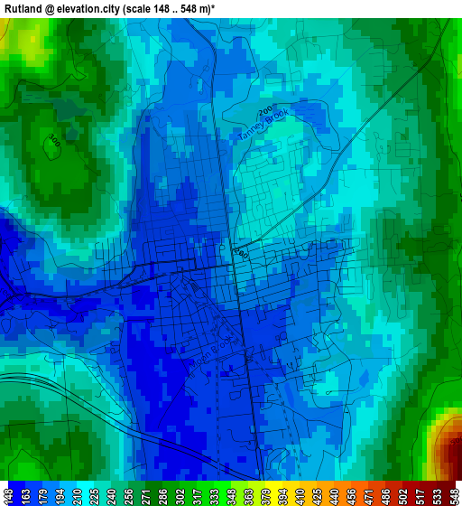
Below is the Elevation map of Rutland, which displays elevation range with different colors. Scale of the first map is from 148 to 548 m (486 to 1798 ft) with average elevation of 223.4 meters (=733 ft) [note 1]
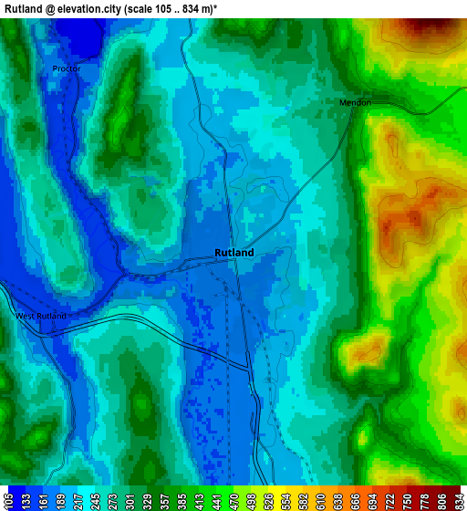
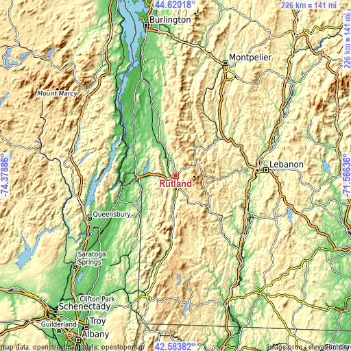
These maps also provides idea of topography and contour of this city, they are displayed at different zoom levels. More info about maps, scale and edge coordinates you can find below images.
| \ | Map #1 | Map #2 | Topo.Map |
| Scale [m] | 148..548 m | 105..834 m | × |
| Scale [ft] | 486..1798 ft | 344..2736 ft | × |
| Average | 223.4 m = 733 ft | 300.5 m = 986 ft | × |
| Width | 7.08 km = 4.4 mi | 14.15 km = 8.8 mi | 226.4 km = 140.7 mi |
| Height | 7.08 km = 4.4 mi | 14.15 km = 8.8 mi | 226.4 km = 140.7 mi |
| ↑Max Latitude | 43.64243° | 43.674223° | 44.62018° |
| Latitude at center | 43.61062° | 43.61062° | 43.61062° |
| ↓Min Latitude | 43.578793° | 43.54695° | 42.58382° |
| ← Min Longitude | -73.016555° | -73.060501° | -74.37886° |
| Longitude center | -72.97261° | -72.97261° | -72.97261° |
| →Max Longitude | -72.928665° | -72.884719° | -71.56636° |
Nearby cities:
Cities around Rutland sort by population:
• Clarendon elevation 182 m
10.5 km,  178°
178°
• Granville 129 m
32.3 km,  225°
225°
• Fair Haven 119 m
23.7 km,  265°
265°
• West Rutland 153 m
6.2 km,  251°
251°
• Brandon 135 m
22.8 km,  336°
336°
• Poultney 131 m
23.7 km,  243°
243°
• Castleton 139 m
16.7 km, 270°
• Danby 213 m
29.5 km, 183°
• Chittenden 348 m
11 km,  10°
10°
• Mount Holly 478 m
21.3 km,  145°
145°
• Leicester 137 m
30.5 km, 339°
• Mendon 317 m
5.8 km,  38°
38°
Multilingual:
 En español:
Rutland elevación 200 m.
 En France:
Rutland élévation 200 m.


Sources and notes:
- [note 1] Map square and city borders are not equal. Map elevation data is calculated only from area inside that square.
- [src 1] Elevation data from geonames database provided with same terms of usage.
- [src 2] The elevation map of Rutland is generated using elevation data from NASA's 3 arcsec (90m) resolution SRTM data.
- [src 3] Base (background) map © OpenStreetMap contributors tiles are generated by Geofabrik and OpenTopoMap.
Copyright & License:
This Rutland Elevation Map is licensed under CC BY-SA. You may reuse any part from this page, if you give a proper credit by linking to this URL:
 More info on terms of use page.