Dover elevation
Dover (Vermont, Windham County), United States elevation is 588 meters and Dover elevation in feet is 1929 ft above sea level [src 1]. Dover is a populated place (feature code) with elevation that is 309 meters (1014 ft) bigger than average city elevation in United States.
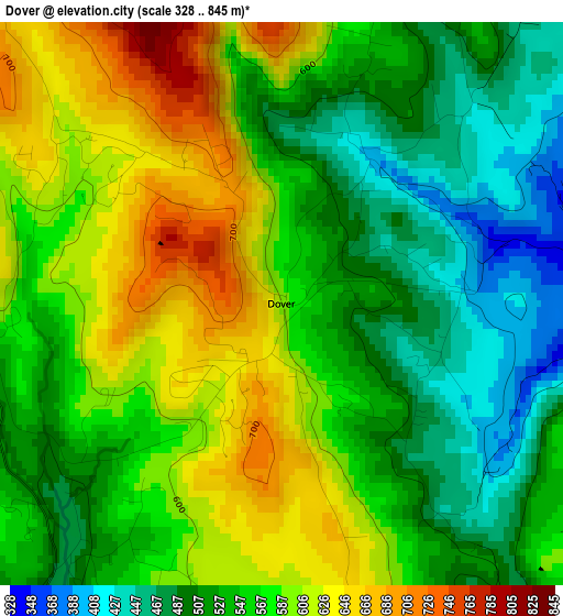
Below is the Elevation map of Dover, which displays elevation range with different colors. Scale of the first map is from 328 to 845 m (1076 to 2772 ft) with average elevation of 557.2 meters (=1828 ft) [note 1]
These maps also provides idea of topography and contour of this city, they are displayed at different zoom levels. More info about maps, scale and edge coordinates you can find below images.
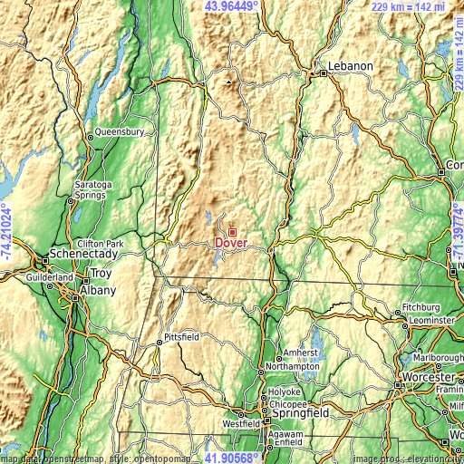
| \ | Map #1 | Topo.Map |
| Scale [m] | 328..845 m | × |
| Scale [ft] | 1076..2772 ft | × |
| Average | 557.2 m = 1828 ft | × |
| Width | 7.15 km = 4.4 mi | 228.9 km = 142.2 mi |
| Height | 7.15 km = 4.4 mi | 228.9 km = 142.2 mi |
| ↑Max Latitude | 42.975851° | 43.96449° |
| Latitude at center | 42.94369° | 42.94369° |
| ↓Min Latitude | 42.911513° | 41.90568° |
| ← Min Longitude | -72.847935° | -74.21024° |
| Longitude center | -72.80399° | -72.80399° |
| →Max Longitude | -72.760045° | -71.39774° |
Nearby cities:
Cities around Dover sort by population:
• Bennington elevation 208 m
32.8 km,  257°
257°
• Brattleboro 79 m
22.5 km,  117°
117°
• Chesterfield 259 m
27.9 km,  102°
102°
• West Brattleboro 149 m
19 km, 120°
• Westmoreland 129 m
29.5 km,  86°
86°
• Colrain 187 m
31.3 km,  163°
163°
• Londonderry 352 m
31.4 km,  359°
359°
• Hinsdale 70 m
31.2 km, 124°
• Arlington 201 m
32 km,  297°
297°
• Townshend 176 m
16 km,  43°
43°
• Jamaica 223 m
17.5 km,  6°
6°
• Newfane 171 m
12.9 km,  68°
68°
Multilingual:
 En español:
Dover elevación 588 m.
 En France:
Dover élévation 588 m.


Sources and notes:
- [note 1] Map square and city borders are not equal. Map elevation data is calculated only from area inside that square.
- [src 1] Elevation data from geonames database provided with same terms of usage.
- [src 2] The elevation map of Dover is generated using elevation data from NASA's 3 arcsec (90m) resolution SRTM data.
- [src 3] Base (background) map © OpenStreetMap contributors tiles are generated by Geofabrik and OpenTopoMap.
Copyright & License:
This Dover Elevation Map is licensed under CC BY-SA. You may reuse any part from this page, if you give a proper credit by linking to this URL:
 More info on terms of use page.