Townshend elevation
Townshend (Vermont, Windham County), United States elevation is 176 meters and Townshend elevation in feet is 577 ft above sea level [src 1]. Townshend is a populated place (feature code) with elevation that is 103 meters (338 ft) smaller than average city elevation in United States.
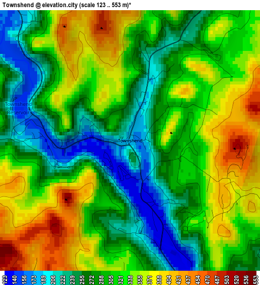
Below is the Elevation map of Townshend, which displays elevation range with different colors. Scale of the first map is from 123 to 553 m (404 to 1814 ft) with average elevation of 309.9 meters (=1017 ft) [note 1]
These maps also provides idea of topography and contour of this city, they are displayed at different zoom levels. More info about maps, scale and edge coordinates you can find below images.
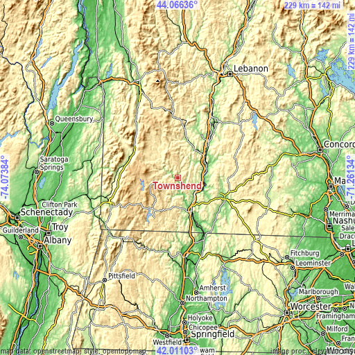
| \ | Map #1 | Topo.Map |
| Scale [m] | 123..553 m | × |
| Scale [ft] | 404..1814 ft | × |
| Average | 309.9 m = 1017 ft | × |
| Width | 7.14 km = 4.4 mi | 228.5 km = 142 mi |
| Height | 7.14 km = 4.4 mi | 228.5 km = 142 mi |
| ↑Max Latitude | 43.079406° | 44.06636° |
| Latitude at center | 43.0473° | 43.0473° |
| ↓Min Latitude | 43.015177° | 42.01103° |
| ← Min Longitude | -72.711535° | -74.07384° |
| Longitude center | -72.66759° | -72.66759° |
| →Max Longitude | -72.623645° | -71.26134° |
Nearby cities:
Cities around Townshend sort by population:
• Brattleboro elevation 79 m
23.6 km,  157°
157°
• Rockingham 151 m
21.3 km,  42°
42°
• Chesterfield 259 m
24 km,  137°
137°
• Bellows Falls 102 m
20.5 km,  62°
62°
• Chester 188 m
24.7 km,  13°
13°
• West Brattleboro 149 m
21.9 km,  166°
166°
• Alstead 148 m
27.4 km,  65°
65°
• Westmoreland 129 m
20.6 km,  117°
117°
• Londonderry 352 m
22.9 km,  330°
330°
• Dover 588 m
16 km,  223°
223°
• Jamaica 223 m
10.8 km,  303°
303°
• Newfane 171 m
6.9 km, 172°
Multilingual:
 En español:
Townshend elevación 176 m.
 En France:
Townshend élévation 176 m.
 Auf Deutsch:
Townshend höhe über dem Meeresspiegel ist 176 m.

Sources and notes:
- [note 1] Map square and city borders are not equal. Map elevation data is calculated only from area inside that square.
- [src 1] Elevation data from geonames database provided with same terms of usage.
- [src 2] The elevation map of Townshend is generated using elevation data from NASA's 3 arcsec (90m) resolution SRTM data.
- [src 3] Base (background) map © OpenStreetMap contributors tiles are generated by Geofabrik and OpenTopoMap.
Copyright & License:
This Townshend Elevation Map is licensed under CC BY-SA. You may reuse any part from this page, if you give a proper credit by linking to this URL:
 More info on terms of use page.