Bennington elevation
Bennington (Vermont, Bennington County), United States elevation is 208 meters and Bennington elevation in feet is 682 ft above sea level [src 1]. Bennington is a populated place (feature code) with elevation that is 71 meters (233 ft) smaller than average city elevation in United States.
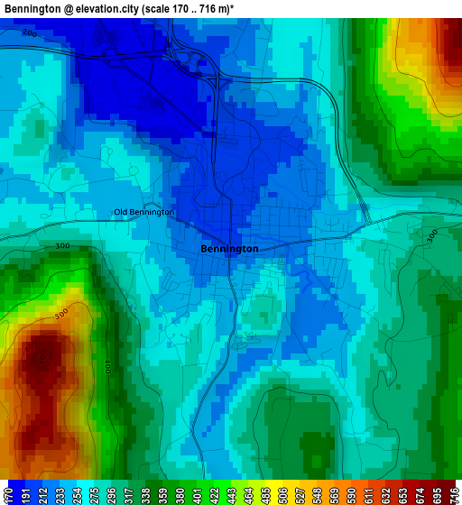
Below is the Elevation map of Bennington, which displays elevation range with different colors. Scale of the first map is from 170 to 716 m (558 to 2349 ft) with average elevation of 305.9 meters (=1004 ft) [note 1]
These maps also provides idea of topography and contour of this city, they are displayed at different zoom levels. More info about maps, scale and edge coordinates you can find below images.
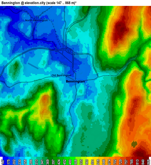
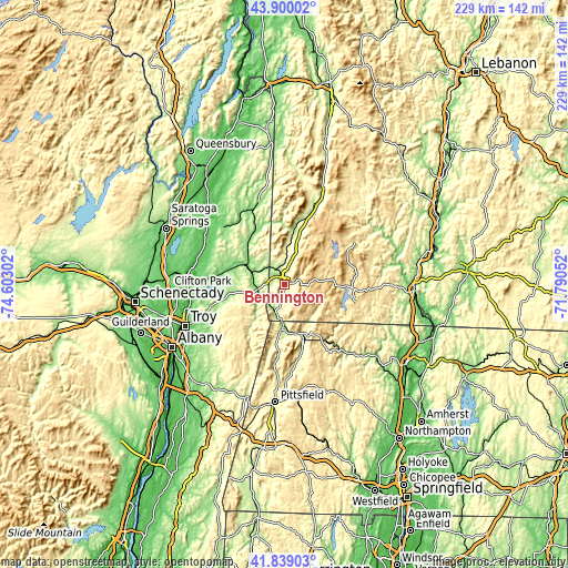
| \ | Map #1 | Map #2 | Topo.Map |
| Scale [m] | 170..716 m | 147..868 m | × |
| Scale [ft] | 558..2349 ft | 482..2848 ft | × |
| Average | 305.9 m = 1004 ft | 385.2 m = 1264 ft | × |
| Width | 7.16 km = 4.4 mi | 14.32 km = 8.9 mi | 229.2 km = 142.4 mi |
| Height | 7.16 km = 4.4 mi | 14.32 km = 8.9 mi | 229.2 km = 142.4 mi |
| ↑Max Latitude | 42.910325° | 42.942503° | 43.90002° |
| Latitude at center | 42.87813° | 42.87813° | 42.87813° |
| ↓Min Latitude | 42.845918° | 42.81369° | 41.83903° |
| ← Min Longitude | -73.240715° | -73.284661° | -74.60302° |
| Longitude center | -73.19677° | -73.19677° | -73.19677° |
| →Max Longitude | -73.152825° | -73.108879° | -71.79052° |
Nearby cities:
Cities around Bennington sort by population:
• North Adams elevation 222 m
21 km,  159°
159°
• Adams 240 m
29 km,  167°
167°
• Williamstown 214 m
18.5 km,  181°
181°
• Pownal 184 m
12.9 km,  194°
194°
• Hoosick Falls 139 m
12.9 km,  281°
281°
• Manchester Center 225 m
35.1 km,  18°
18°
• Cambridge 151 m
22.4 km,  318°
318°
• Greenwich 117 m
34.1 km,  313°
313°
• North Bennington 196 m
6.9 km,  327°
327°
• Dover 588 m
32.8 km,  77°
77°
• Arlington 201 m
22.1 km,  9°
9°
• Poestenkill 149 m
36.6 km,  235°
235°
Multilingual:
 En español:
Bennington elevación 208 m.
 En France:
Bennington élévation 208 m.
 Auf Deutsch:
Bennington höhe über dem Meeresspiegel ist 208 m.

Sources and notes:
- [note 1] Map square and city borders are not equal. Map elevation data is calculated only from area inside that square.
- [src 1] Elevation data from geonames database provided with same terms of usage.
- [src 2] The elevation map of Bennington is generated using elevation data from NASA's 3 arcsec (90m) resolution SRTM data.
- [src 3] Base (background) map © OpenStreetMap contributors tiles are generated by Geofabrik and OpenTopoMap.
Copyright & License:
This Bennington Elevation Map is licensed under CC BY-SA. You may reuse any part from this page, if you give a proper credit by linking to this URL:
 More info on terms of use page.