Pownal elevation
Pownal (Vermont, Bennington County), United States elevation is 184 meters and Pownal elevation in feet is 604 ft above sea level [src 1]. Pownal is a populated place (feature code) with elevation that is 95 meters (312 ft) smaller than average city elevation in United States.
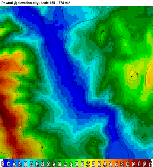
Below is the Elevation map of Pownal, which displays elevation range with different colors. Scale of the first map is from 155 to 774 m (509 to 2539 ft) with average elevation of 345.1 meters (=1132 ft) [note 1]
These maps also provides idea of topography and contour of this city, they are displayed at different zoom levels. More info about maps, scale and edge coordinates you can find below images.
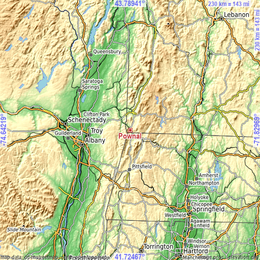
| \ | Map #1 | Topo.Map |
| Scale [m] | 155..774 m | × |
| Scale [ft] | 509..2539 ft | × |
| Average | 345.1 m = 1132 ft | × |
| Width | 7.17 km = 4.5 mi | 229.6 km = 142.7 mi |
| Height | 7.17 km = 4.5 mi | 229.6 km = 142.7 mi |
| ↑Max Latitude | 42.797893° | 43.78941° |
| Latitude at center | 42.76564° | 42.76564° |
| ↓Min Latitude | 42.73337° | 41.72467° |
| ← Min Longitude | -73.279885° | -74.64219° |
| Longitude center | -73.23594° | -73.23594° |
| →Max Longitude | -73.191995° | -71.82969° |
Nearby cities:
Cities around Pownal sort by population:
• North Adams elevation 222 m
12.6 km,  124°
124°
• Bennington 208 m
12.9 km,  14°
14°
• Dalton 348 m
33 km,  170°
170°
• Adams 240 m
18.5 km,  148°
148°
• Williamstown 214 m
6.5 km,  156°
156°
• Hoosick Falls 139 m
17.8 km,  327°
327°
• Lanesborough 346 m
27.6 km,  178°
178°
• West Sand Lake 161 m
33.4 km,  245°
245°
• Cambridge 151 m
31.5 km,  337°
337°
• Averill Park 237 m
29.8 km,  240°
240°
• North Bennington 196 m
18.3 km,  358°
358°
• Poestenkill 149 m
28.1 km, 252°
Multilingual:
 En español:
Pownal elevación 184 m.
 En France:
Pownal élévation 184 m.


Sources and notes:
- [note 1] Map square and city borders are not equal. Map elevation data is calculated only from area inside that square.
- [src 1] Elevation data from geonames database provided with same terms of usage.
- [src 2] The elevation map of Pownal is generated using elevation data from NASA's 3 arcsec (90m) resolution SRTM data.
- [src 3] Base (background) map © OpenStreetMap contributors tiles are generated by Geofabrik and OpenTopoMap.
Copyright & License:
This Pownal Elevation Map is licensed under CC BY-SA. You may reuse any part from this page, if you give a proper credit by linking to this URL:
 More info on terms of use page.