Dalton elevation
Dalton (Massachusetts, Berkshire County), United States elevation is 348 meters and Dalton elevation in feet is 1142 ft above sea level [src 1]. Dalton is a populated place (feature code) with elevation that is 69 meters (226 ft) bigger than average city elevation in United States.
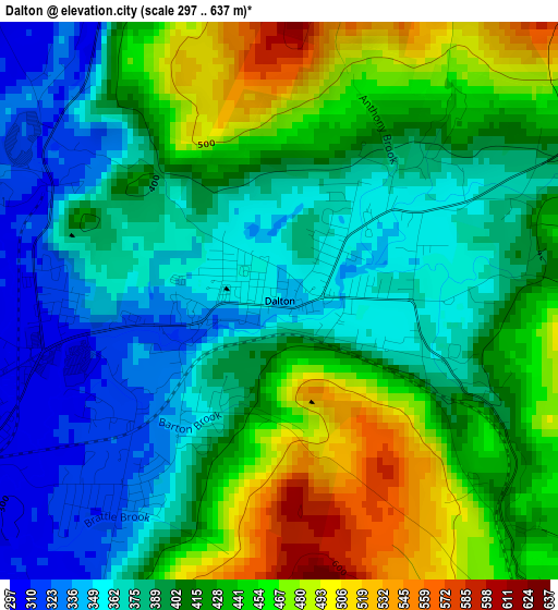
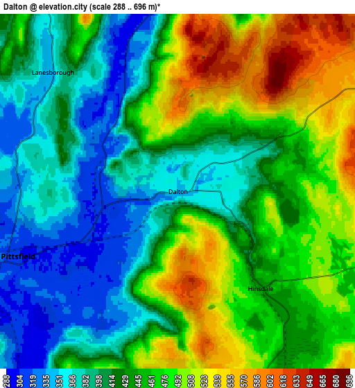
Below is the Elevation map of Dalton, which displays elevation range with different colors. Scale of the first map is from 297 to 637 m (974 to 2090 ft) with average elevation of 409.7 meters (=1344 ft) [note 1]
These maps also provides idea of topography and contour of this city, they are displayed at different zoom levels. More info about maps, scale and edge coordinates you can find below images.
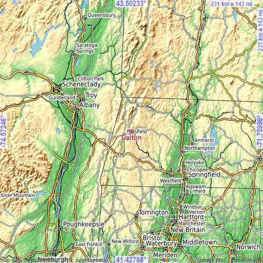
| \ | Map #1 | Map #2 | Topo.Map |
| Scale [m] | 297..637 m | 288..696 m | × |
| Scale [ft] | 974..2090 ft | 945..2283 ft | × |
| Average | 409.7 m = 1344 ft | 440.1 m = 1444 ft | × |
| Width | 7.21 km = 4.5 mi | 14.42 km = 9 mi | 230.7 km = 143.4 mi |
| Height | 7.21 km = 4.5 mi | 14.42 km = 9 mi | 230.6 km = 143.3 mi |
| ↑Max Latitude | 42.506105° | 42.538493° | 43.50233° |
| Latitude at center | 42.4737° | 42.4737° | 42.4737° |
| ↓Min Latitude | 42.441278° | 42.408839° | 41.42788° |
| ← Min Longitude | -73.210155° | -73.254101° | -74.57246° |
| Longitude center | -73.16621° | -73.16621° | -73.16621° |
| →Max Longitude | -73.122265° | -73.078319° | -71.75996° |
Nearby cities:
Cities around Dalton sort by population:
• Pittsfield elevation 304 m
7 km,  247°
247°
• North Adams 222 m
25.7 km,  10°
10°
• Adams 240 m
17.2 km, 13°
• Williamstown 214 m
26.7 km,  353°
353°
• Lanesborough 346 m
7 km,  313°
313°
• Stockbridge 253 m
24.3 km,  211°
211°
• Lee 269 m
20 km,  199°
199°
• Hinsdale 439 m
5.1 km,  139°
139°
• Becket 372 m
17.2 km,  156°
156°
• Lenox 384 m
16.3 km,  216°
216°
• Richmond 322 m
20 km,  235°
235°
• West Stockbridge 288 m
21.7 km,  229°
229°
Multilingual:
 En español:
Dalton elevación 348 m.
 En France:
Dalton élévation 348 m.


Sources and notes:
- [note 1] Map square and city borders are not equal. Map elevation data is calculated only from area inside that square.
- [src 1] Elevation data from geonames database provided with same terms of usage.
- [src 2] The elevation map of Dalton is generated using elevation data from NASA's 3 arcsec (90m) resolution SRTM data.
- [src 3] Base (background) map © OpenStreetMap contributors tiles are generated by Geofabrik and OpenTopoMap.
Copyright & License:
This Dalton Elevation Map is licensed under CC BY-SA. You may reuse any part from this page, if you give a proper credit by linking to this URL:
 More info on terms of use page.