Sisseton elevation
Sisseton (South Dakota, Roberts County), United States elevation is 372 meters and Sisseton elevation in feet is 1220 ft above sea level [src 1]. Sisseton is a seat of a second-order administrative division (feature code) with elevation that is 93 meters (305 ft) bigger than average city elevation in United States.
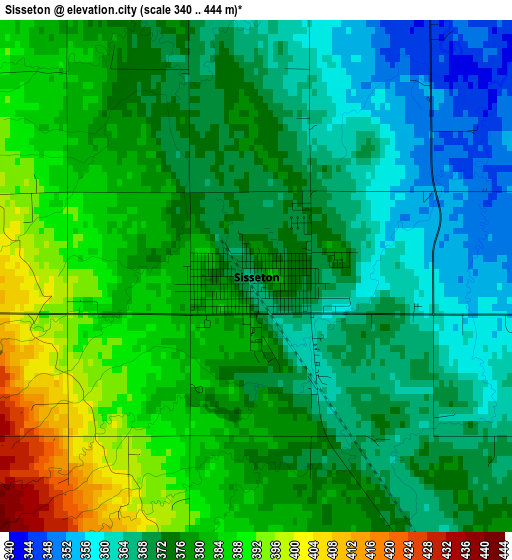
Below is the Elevation map of Sisseton, which displays elevation range with different colors. Scale of the first map is from 340 to 444 m (1115 to 1457 ft) with average elevation of 375.2 meters (=1231 ft) [note 1]
These maps also provides idea of topography and contour of this city, they are displayed at different zoom levels. More info about maps, scale and edge coordinates you can find below images.
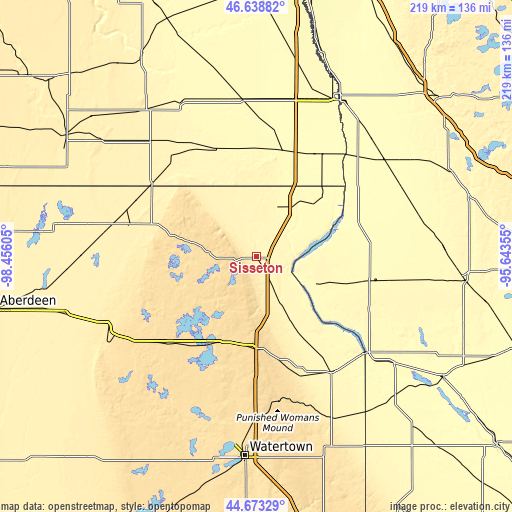
| \ | Map #1 | Topo.Map |
| Scale [m] | 340..444 m | × |
| Scale [ft] | 1115..1457 ft | × |
| Average | 375.2 m = 1231 ft | × |
| Width | 6.83 km = 4.2 mi | 218.5 km = 135.8 mi |
| Height | 6.83 km = 4.2 mi | 218.5 km = 135.8 mi |
| ↑Max Latitude | 45.695383° | 46.63882° |
| Latitude at center | 45.66468° | 45.66468° |
| ↓Min Latitude | 45.63396° | 44.67329° |
| ← Min Longitude | -97.093745° | -98.45605° |
| Longitude center | -97.0498° | -97.0498° |
| →Max Longitude | -97.005855° | -95.64355° |
Nearby cities:
Cities around Sisseton sort by population:
• Watertown elevation 530 m
85.2 km,  183°
183°
• Wahpeton 294 m
75.1 km,  27°
27°
• Morris 343 m
88.8 km,  95°
95°
• Breckenridge 291 m
75.5 km, 28°
• Milbank 351 m
59.1 km,  146°
146°
• Ortonville 309 m
61.9 km,  130°
130°
• Webster 565 m
52.1 km,  224°
224°
• Groton 397 m
85.2 km,  253°
253°
• Wheaton 311 m
45.5 km,  70°
70°
• Britton 414 m
56.2 km,  284°
284°
• Elbow Lake 373 m
90.8 km, 66°
• Forman 382 m
67 km,  317°
317°
Multilingual:
 En español:
Sisseton elevación 372 m.
 En France:
Sisseton élévation 372 m.
 Auf Deutsch:
Sisseton höhe über dem Meeresspiegel ist 372 m.

Sources and notes:
- [note 1] Map square and city borders are not equal. Map elevation data is calculated only from area inside that square.
- [src 1] Elevation data from geonames database provided with same terms of usage.
- [src 2] The elevation map of Sisseton is generated using elevation data from NASA's 3 arcsec (90m) resolution SRTM data.
- [src 3] Base (background) map © OpenStreetMap contributors tiles are generated by Geofabrik and OpenTopoMap.
Copyright & License:
This Sisseton Elevation Map is licensed under CC BY-SA. You may reuse any part from this page, if you give a proper credit by linking to this URL:
 More info on terms of use page.