Wahpeton elevation
Wahpeton (North Dakota, Richland County), United States elevation is 294 meters and Wahpeton elevation in feet is 965 ft above sea level [src 1]. Wahpeton is a seat of a second-order administrative division (feature code) with elevation that is 15 meters (49 ft) bigger than average city elevation in United States.
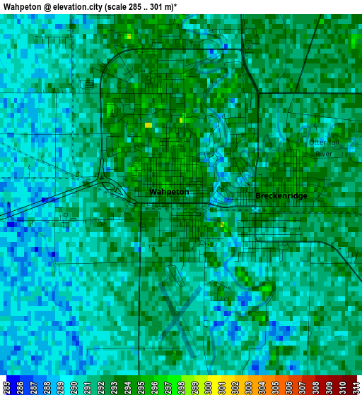
Below is the Elevation map of Wahpeton, which displays elevation range with different colors. Scale of the first map is from 285 to 301 m (935 to 988 ft) with average elevation of 291 meters (=955 ft) [note 1]
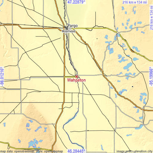
These maps also provides idea of topography and contour of this city, they are displayed at different zoom levels. More info about maps, scale and edge coordinates you can find below images.
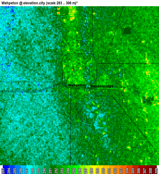
| \ | Map #1 | Map #2 | Topo.Map |
| Scale [m] | 285..301 m | 283..306 m | × |
| Scale [ft] | 935..988 ft | 928..1004 ft | × |
| Average | 291 m = 955 ft | 290.8 m = 954 ft | × |
| Width | 6.76 km = 4.2 mi | 13.51 km = 8.4 mi | 216.2 km = 134.3 mi |
| Height | 6.76 km = 4.2 mi | 13.51 km = 8.4 mi | 216.2 km = 134.3 mi |
| ↑Max Latitude | 46.295612° | 46.325967° | 47.22879° |
| Latitude at center | 46.26524° | 46.26524° | 46.26524° |
| ↓Min Latitude | 46.234851° | 46.204446° | 45.28445° |
| ← Min Longitude | -96.649855° | -96.693801° | -98.01216° |
| Longitude center | -96.60591° | -96.60591° | -96.60591° |
| →Max Longitude | -96.561965° | -96.518019° | -95.19966° |
Nearby cities:
Cities around Wahpeton sort by population:
• Fargo elevation 279 m
69.5 km,  348°
348°
• Moorhead 273 m
68.8 km, 349°
• West Fargo 274 m
71.4 km,  341°
341°
• Fergus Falls 361 m
40.7 km,  87°
87°
• Dilworth 277 m
68.4 km, 353°
• Breckenridge 291 m
1.4 km,  97°
97°
• Barnesville 311 m
45.3 km,  18°
18°
• Horace 278 m
59.4 km, 337°
• Pelican Rapids 397 m
52.5 km,  49°
49°
• Glyndon 284 m
67.9 km,  1°
1°
• Wheaton 311 m
51.9 km,  170°
170°
• Elbow Lake 373 m
57.1 km,  121°
121°
Multilingual:
 En español:
Wahpeton elevación 294 m.
 En France:
Wahpeton élévation 294 m.
 Auf Deutsch:
Wahpeton höhe über dem Meeresspiegel ist 294 m.

Sources and notes:
- [note 1] Map square and city borders are not equal. Map elevation data is calculated only from area inside that square.
- [src 1] Elevation data from geonames database provided with same terms of usage.
- [src 2] The elevation map of Wahpeton is generated using elevation data from NASA's 3 arcsec (90m) resolution SRTM data.
- [src 3] Base (background) map © OpenStreetMap contributors tiles are generated by Geofabrik and OpenTopoMap.
Copyright & License:
This Wahpeton Elevation Map is licensed under CC BY-SA. You may reuse any part from this page, if you give a proper credit by linking to this URL:
 More info on terms of use page.