Fargo elevation
Fargo (North Dakota, Cass County), United States elevation is 279 meters and Fargo elevation in feet is 915 ft above sea level [src 1]. Fargo is a seat of a second-order administrative division (feature code) with elevation that is 0 meters (0 ft) bigger than average city elevation in United States.
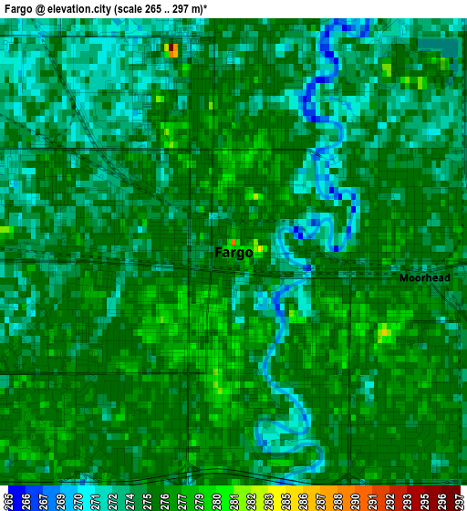
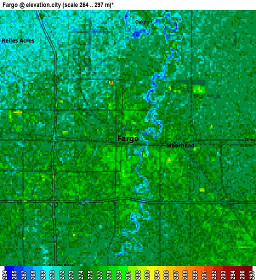
Below is the Elevation map of Fargo, which displays elevation range with different colors. Scale of the first map is from 265 to 297 m (869 to 974 ft) with average elevation of 274.9 meters (=902 ft) [note 1]
These maps also provides idea of topography and contour of this city, they are displayed at different zoom levels. More info about maps, scale and edge coordinates you can find below images.
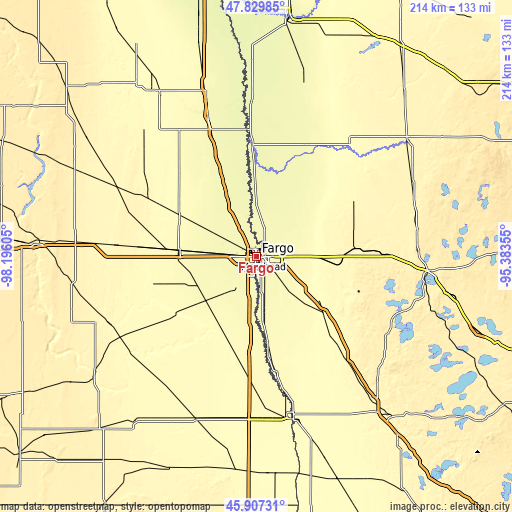
| \ | Map #1 | Map #2 | Topo.Map |
| Scale [m] | 265..297 m | 264..297 m | × |
| Scale [ft] | 869..974 ft | 866..974 ft | × |
| Average | 274.9 m = 902 ft | 274 m = 899 ft | × |
| Width | 6.68 km = 4.2 mi | 13.36 km = 8.3 mi | 213.8 km = 132.8 mi |
| Height | 6.68 km = 4.2 mi | 13.36 km = 8.3 mi | 213.8 km = 132.8 mi |
| ↑Max Latitude | 46.907221° | 46.937235° | 47.82985° |
| Latitude at center | 46.87719° | 46.87719° | 46.87719° |
| ↓Min Latitude | 46.847142° | 46.817077° | 45.90731° |
| ← Min Longitude | -96.833745° | -96.877691° | -98.19605° |
| Longitude center | -96.7898° | -96.7898° | -96.7898° |
| →Max Longitude | -96.745855° | -96.701909° | -95.38355° |
Nearby cities:
Cities around Fargo sort by population:
• Moorhead elevation 273 m
1.6 km,  103°
103°
• West Fargo 274 m
8.4 km,  268°
268°
• Dilworth 277 m
6.6 km,  90°
90°
• Barnesville 311 m
37.7 km,  131°
131°
• Horace 278 m
15.8 km,  213°
213°
• Casselton 285 m
32.1 km, 274°
• Hawley 350 m
36 km, 89°
• Ada 276 m
51.4 km,  23°
23°
• Hillsboro 277 m
62.1 km,  340°
340°
• Oakport 273 m
6.1 km,  7°
7°
• Glyndon 284 m
16 km, 90°
• Sheldon 329 m
62.5 km,  238°
238°
Multilingual:
 En español:
Fargo elevación 279 m.
 En France:
Fargo élévation 279 m.


Sources and notes:
- [note 1] Map square and city borders are not equal. Map elevation data is calculated only from area inside that square.
- [src 1] Elevation data from geonames database provided with same terms of usage.
- [src 2] The elevation map of Fargo is generated using elevation data from NASA's 3 arcsec (90m) resolution SRTM data.
- [src 3] Base (background) map © OpenStreetMap contributors tiles are generated by Geofabrik and OpenTopoMap.
Copyright & License:
This Fargo Elevation Map is licensed under CC BY-SA. You may reuse any part from this page, if you give a proper credit by linking to this URL:
 More info on terms of use page.