Britton elevation
Britton (South Dakota, Marshall County), United States elevation is 414 meters and Britton elevation in feet is 1358 ft above sea level [src 1]. Britton is a seat of a second-order administrative division (feature code) with elevation that is 135 meters (443 ft) bigger than average city elevation in United States.
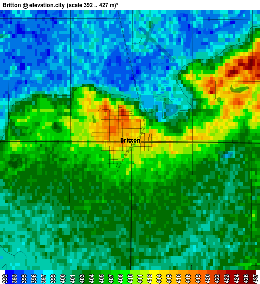
Below is the Elevation map of Britton, which displays elevation range with different colors. Scale of the first map is from 392 to 427 m (1286 to 1401 ft) with average elevation of 403 meters (=1322 ft) [note 1]
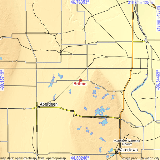
These maps also provides idea of topography and contour of this city, they are displayed at different zoom levels. More info about maps, scale and edge coordinates you can find below images.
| \ | Map #1 | Topo.Map |
| Scale [m] | 392..427 m | × |
| Scale [ft] | 1286..1401 ft | × |
| Average | 403 m = 1322 ft | × |
| Width | 6.81 km = 4.2 mi | 218.1 km = 135.5 mi |
| Height | 6.81 km = 4.2 mi | 218 km = 135.5 mi |
| ↑Max Latitude | 45.822253° | 46.76353° |
| Latitude at center | 45.79162° | 45.79162° |
| ↓Min Latitude | 45.76097° | 44.80246° |
| ← Min Longitude | -97.794885° | -99.15719° |
| Longitude center | -97.75094° | -97.75094° |
| →Max Longitude | -97.706995° | -96.34469° |
Nearby cities:
Cities around Britton sort by population:
• Aberdeen elevation 397 m
67.8 km,  237°
237°
• Sisseton 372 m
56.2 km,  104°
104°
• Lisbon 331 m
72.5 km,  4°
4°
• Webster 565 m
54.2 km,  160°
160°
• Oakes 401 m
46.7 km,  325°
325°
• Groton 397 m
46.9 km,  215°
215°
• Wheaton 311 m
97 km,  89°
89°
• Ellendale 442 m
64.5 km,  291°
291°
• Clark 544 m
101.6 km,  179°
179°
• Forman 382 m
36.2 km,  14°
14°
• Leola 483 m
92.6 km,  265°
265°
• Sheldon 329 m
90.5 km, 12°
Multilingual:
 En español:
Britton elevación 414 m.
 En France:
Britton élévation 414 m.


Sources and notes:
- [note 1] Map square and city borders are not equal. Map elevation data is calculated only from area inside that square.
- [src 1] Elevation data from geonames database provided with same terms of usage.
- [src 2] The elevation map of Britton is generated using elevation data from NASA's 3 arcsec (90m) resolution SRTM data.
- [src 3] Base (background) map © OpenStreetMap contributors tiles are generated by Geofabrik and OpenTopoMap.
Copyright & License:
This Britton Elevation Map is licensed under CC BY-SA. You may reuse any part from this page, if you give a proper credit by linking to this URL:
 More info on terms of use page.