Leola elevation
Leola (South Dakota, McPherson County), United States elevation is 483 meters and Leola elevation in feet is 1585 ft above sea level [src 1]. Leola is a seat of a second-order administrative division (feature code) with elevation that is 204 meters (669 ft) bigger than average city elevation in United States.
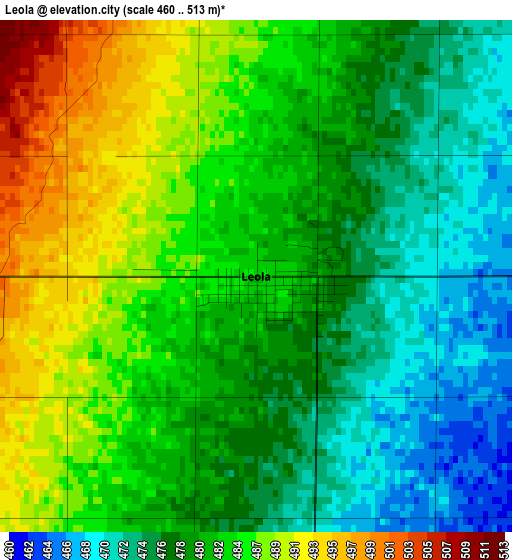
Below is the Elevation map of Leola, which displays elevation range with different colors. Scale of the first map is from 460 to 513 m (1509 to 1683 ft) with average elevation of 481.5 meters (=1580 ft) [note 1]
These maps also provides idea of topography and contour of this city, they are displayed at different zoom levels. More info about maps, scale and edge coordinates you can find below images.
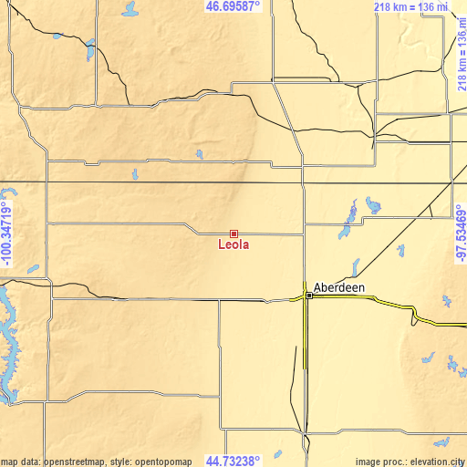
| \ | Map #1 | Topo.Map |
| Scale [m] | 460..513 m | × |
| Scale [ft] | 1509..1683 ft | × |
| Average | 481.5 m = 1580 ft | × |
| Width | 6.82 km = 4.2 mi | 218.3 km = 135.6 mi |
| Height | 6.82 km = 4.2 mi | 218.3 km = 135.6 mi |
| ↑Max Latitude | 45.753421° | 46.69587° |
| Latitude at center | 45.72275° | 45.72275° |
| ↓Min Latitude | 45.692062° | 44.73238° |
| ← Min Longitude | -98.984885° | -100.34719° |
| Longitude center | -98.94094° | -98.94094° |
| →Max Longitude | -98.896995° | -97.53469° |
Nearby cities:
Cities around Leola sort by population:
• Aberdeen elevation 397 m
45.5 km,  129°
129°
• Redfield 395 m
99.8 km,  160°
160°
• Oakes 401 m
80.4 km,  54°
54°
• Groton 397 m
72.3 km,  115°
115°
• Ellendale 442 m
44.7 km, 45°
• Britton 414 m
92.6 km,  85°
85°
• Ipswich 465 m
31.7 km,  192°
192°
• Napoleon 597 m
108.3 km,  323°
323°
• Faulkton 482 m
77.8 km, 190°
• Ashley 614 m
48.1 km, 316°
• Selby 577 m
88.2 km,  254°
254°
• Mound City 526 m
87.5 km,  270°
270°
Multilingual:
 En español:
Leola elevación 483 m.
 En France:
Leola élévation 483 m.


Sources and notes:
- [note 1] Map square and city borders are not equal. Map elevation data is calculated only from area inside that square.
- [src 1] Elevation data from geonames database provided with same terms of usage.
- [src 2] The elevation map of Leola is generated using elevation data from NASA's 3 arcsec (90m) resolution SRTM data.
- [src 3] Base (background) map © OpenStreetMap contributors tiles are generated by Geofabrik and OpenTopoMap.
Copyright & License:
This Leola Elevation Map is licensed under CC BY-SA. You may reuse any part from this page, if you give a proper credit by linking to this URL:
 More info on terms of use page.