Selby elevation
Selby (South Dakota, Walworth County), United States elevation is 577 meters and Selby elevation in feet is 1893 ft above sea level [src 1]. Selby is a seat of a second-order administrative division (feature code) with elevation that is 298 meters (978 ft) bigger than average city elevation in United States.
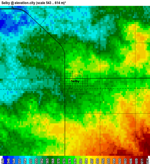
Below is the Elevation map of Selby, which displays elevation range with different colors. Scale of the first map is from 543 to 614 m (1781 to 2014 ft) with average elevation of 573 meters (=1880 ft) [note 1]
These maps also provides idea of topography and contour of this city, they are displayed at different zoom levels. More info about maps, scale and edge coordinates you can find below images.
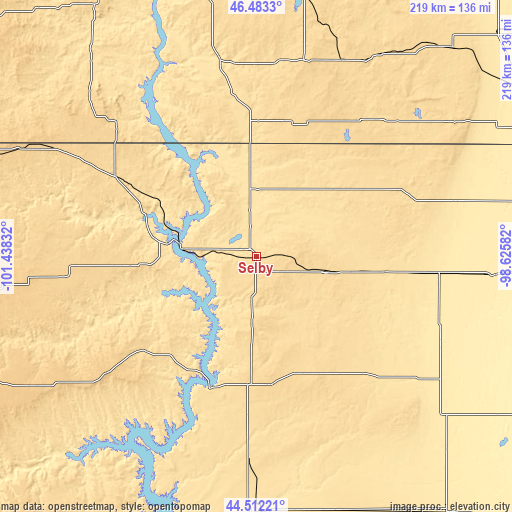
| \ | Map #1 | Topo.Map |
| Scale [m] | 543..614 m | × |
| Scale [ft] | 1781..2014 ft | × |
| Average | 573 m = 1880 ft | × |
| Width | 6.85 km = 4.3 mi | 219.2 km = 136.2 mi |
| Height | 6.85 km = 4.3 mi | 219.2 km = 136.2 mi |
| ↑Max Latitude | 45.53717° | 46.4833° |
| Latitude at center | 45.50638° | 45.50638° |
| ↓Min Latitude | 45.475573° | 44.51221° |
| ← Min Longitude | -100.076015° | -101.43832° |
| Longitude center | -100.03207° | -100.03207° |
| →Max Longitude | -99.988125° | -98.62582° |
Nearby cities:
Cities around Selby sort by population:
• Mobridge elevation 505 m
31 km,  276°
276°
• North Eagle Butte 735 m
109.4 km,  239°
239°
• Gettysburg 629 m
55.3 km,  173°
173°
• Linton 524 m
86 km,  349°
349°
• Ipswich 465 m
78.5 km,  95°
95°
• Faulkton 482 m
88.3 km,  126°
126°
• Ashley 614 m
77.9 km,  41°
41°
• Onida 568 m
88.8 km,  181°
181°
• Timber Lake 662 m
81.7 km,  263°
263°
• Leola 483 m
88.2 km,  74°
74°
• Fort Yates 498 m
79.5 km,  324°
324°
• Mound City 526 m
24.5 km, 353°
Multilingual:
 En español:
Selby elevación 577 m.
 En France:
Selby élévation 577 m.


Sources and notes:
- [note 1] Map square and city borders are not equal. Map elevation data is calculated only from area inside that square.
- [src 1] Elevation data from geonames database provided with same terms of usage.
- [src 2] The elevation map of Selby is generated using elevation data from NASA's 3 arcsec (90m) resolution SRTM data.
- [src 3] Base (background) map © OpenStreetMap contributors tiles are generated by Geofabrik and OpenTopoMap.
Copyright & License:
This Selby Elevation Map is licensed under CC BY-SA. You may reuse any part from this page, if you give a proper credit by linking to this URL:
 More info on terms of use page.