Watertown elevation
Watertown (South Dakota, Codington County), United States elevation is 530 meters and Watertown elevation in feet is 1739 ft above sea level [src 1]. Watertown is a seat of a second-order administrative division (feature code) with elevation that is 251 meters (823 ft) bigger than average city elevation in United States.
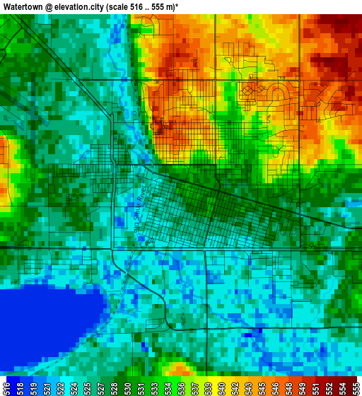
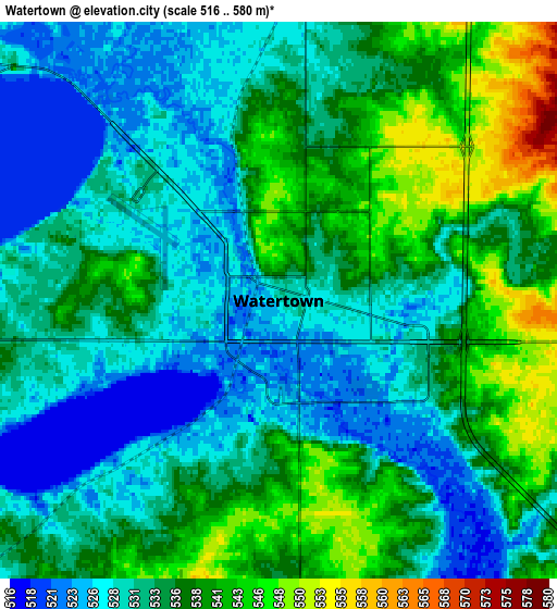
Below is the Elevation map of Watertown, which displays elevation range with different colors. Scale of the first map is from 516 to 555 m (1693 to 1821 ft) with average elevation of 529.5 meters (=1737 ft) [note 1]
These maps also provides idea of topography and contour of this city, they are displayed at different zoom levels. More info about maps, scale and edge coordinates you can find below images.
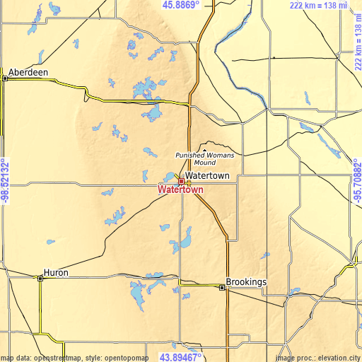
| \ | Map #1 | Map #2 | Topo.Map |
| Scale [m] | 516..555 m | 516..580 m | × |
| Scale [ft] | 1693..1821 ft | 1693..1903 ft | × |
| Average | 529.5 m = 1737 ft | 533.9 m = 1752 ft | × |
| Width | 6.92 km = 4.3 mi | 13.84 km = 8.6 mi | 221.5 km = 137.6 mi |
| Height | 6.92 km = 4.3 mi | 13.84 km = 8.6 mi | 221.5 km = 137.6 mi |
| ↑Max Latitude | 44.93053° | 44.961633° | 45.8869° |
| Latitude at center | 44.89941° | 44.89941° | 44.89941° |
| ↓Min Latitude | 44.868273° | 44.837119° | 43.89467° |
| ← Min Longitude | -97.159015° | -97.202961° | -98.52132° |
| Longitude center | -97.11507° | -97.11507° | -97.11507° |
| →Max Longitude | -97.071125° | -97.027179° | -95.70882° |
Nearby cities:
Cities around Watertown sort by population:
• Brookings elevation 493 m
70 km,  159°
159°
• Milbank 351 m
51.8 km,  46°
46°
• Volga 497 m
65.7 km,  166°
166°
• Ortonville 309 m
69.3 km, 49°
• Webster 565 m
57.7 km,  326°
326°
• Canby 377 m
69.5 km,  107°
107°
• Madison 332 m
73.4 km,  80°
80°
• Dawson 318 m
83.6 km,  87°
87°
• Clear Lake 556 m
38.1 km,  116°
116°
• De Smet 522 m
66.5 km,  211°
211°
• Clark 544 m
48.7 km,  267°
267°
• Hayti 517 m
27.9 km,  194°
194°
Multilingual:
 En español:
Watertown elevación 530 m.
 En France:
Watertown élévation 530 m.
 Auf Deutsch:
Watertown höhe über dem Meeresspiegel ist 530 m.

Sources and notes:
- [note 1] Map square and city borders are not equal. Map elevation data is calculated only from area inside that square.
- [src 1] Elevation data from geonames database provided with same terms of usage.
- [src 2] The elevation map of Watertown is generated using elevation data from NASA's 3 arcsec (90m) resolution SRTM data.
- [src 3] Base (background) map © OpenStreetMap contributors tiles are generated by Geofabrik and OpenTopoMap.
Copyright & License:
This Watertown Elevation Map is licensed under CC BY-SA. You may reuse any part from this page, if you give a proper credit by linking to this URL:
 More info on terms of use page.