Saxonburg elevation
Saxonburg (Pennsylvania, Butler County), United States elevation is 395 meters and Saxonburg elevation in feet is 1296 ft above sea level [src 1]. Saxonburg is a populated place (feature code) with elevation that is 116 meters (381 ft) bigger than average city elevation in United States.
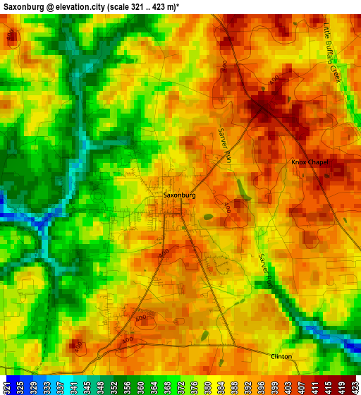
Below is the Elevation map of Saxonburg, which displays elevation range with different colors. Scale of the first map is from 321 to 423 m (1053 to 1388 ft) with average elevation of 383 meters (=1257 ft) [note 1]
These maps also provides idea of topography and contour of this city, they are displayed at different zoom levels. More info about maps, scale and edge coordinates you can find below images.
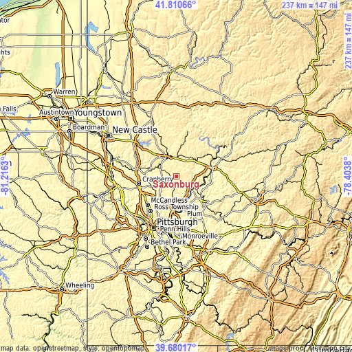
| \ | Map #1 | Topo.Map |
| Scale [m] | 321..423 m | × |
| Scale [ft] | 1053..1388 ft | × |
| Average | 383 m = 1257 ft | × |
| Width | 7.4 km = 4.6 mi | 236.9 km = 147.2 mi |
| Height | 7.4 km = 4.6 mi | 236.9 km = 147.2 mi |
| ↑Max Latitude | 40.787231° | 41.81066° |
| Latitude at center | 40.75395° | 40.75395° |
| ↓Min Latitude | 40.720652° | 39.68017° |
| ← Min Longitude | -79.853995° | -81.2163° |
| Longitude center | -79.81005° | -79.81005° |
| →Max Longitude | -79.766105° | -78.4038° |
Nearby cities:
Cities around Saxonburg sort by population:
• Butler elevation 323 m
13.9 km,  328°
328°
• Homeacre-Lyndora 384 m
16.1 km,  324°
324°
• Tarentum 243 m
17.5 km,  165°
165°
• Meridian 390 m
16.5 km,  309°
309°
• Brackenridge 255 m
17.2 km,  160°
160°
• Meadowood 404 m
12.1 km, 324°
• Oak Hills 373 m
11.7 km, 312°
• Bakerstown 333 m
15.6 km,  222°
222°
• Freeport 244 m
13.8 km,  130°
130°
• Russellton 289 m
16 km,  188°
188°
• Nixon 375 m
10.6 km,  288°
288°
• Curtisville 324 m
12.9 km,  195°
195°
Multilingual:
 En español:
Saxonburg elevación 395 m.
 En France:
Saxonburg élévation 395 m.
 Auf Deutsch:
Saxonburg höhe über dem Meeresspiegel ist 395 m.

Sources and notes:
- [note 1] Map square and city borders are not equal. Map elevation data is calculated only from area inside that square.
- [src 1] Elevation data from geonames database provided with same terms of usage.
- [src 2] The elevation map of Saxonburg is generated using elevation data from NASA's 3 arcsec (90m) resolution SRTM data.
- [src 3] Base (background) map © OpenStreetMap contributors tiles are generated by Geofabrik and OpenTopoMap.
Copyright & License:
This Saxonburg Elevation Map is licensed under CC BY-SA. You may reuse any part from this page, if you give a proper credit by linking to this URL:
 More info on terms of use page.