Bakerstown elevation
Bakerstown (Pennsylvania, Allegheny County), United States elevation is 333 meters and Bakerstown elevation in feet is 1093 ft above sea level [src 1]. Bakerstown is a populated place (feature code) with elevation that is 54 meters (177 ft) bigger than average city elevation in United States.
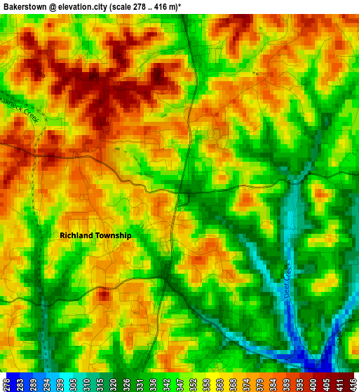
Below is the Elevation map of Bakerstown, which displays elevation range with different colors. Scale of the first map is from 278 to 416 m (912 to 1365 ft) with average elevation of 354.7 meters (=1164 ft) [note 1]
These maps also provides idea of topography and contour of this city, they are displayed at different zoom levels. More info about maps, scale and edge coordinates you can find below images.
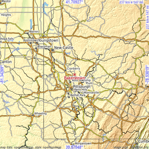
| \ | Map #1 | Topo.Map |
| Scale [m] | 278..416 m | × |
| Scale [ft] | 912..1365 ft | × |
| Average | 354.7 m = 1164 ft | × |
| Width | 7.41 km = 4.6 mi | 237.3 km = 147.5 mi |
| Height | 7.41 km = 4.6 mi | 237.2 km = 147.4 mi |
| ↑Max Latitude | 40.684233° | 41.70927° |
| Latitude at center | 40.6509° | 40.6509° |
| ↓Min Latitude | 40.617551° | 39.57548° |
| ← Min Longitude | -79.980385° | -81.34269° |
| Longitude center | -79.93644° | -79.93644° |
| →Max Longitude | -79.892495° | -78.53019° |
Nearby cities:
Cities around Bakerstown sort by population:
• Cranberry Township elevation 315 m
14.9 km,  284°
284°
• Allison Park 276 m
10.3 km,  190°
190°
• Franklin Park 376 m
14.8 km,  239°
239°
• Glenshaw 334 m
13.4 km, 191°
• Fox Run 333 m
13.6 km,  294°
294°
• Seven Fields 331 m
11.6 km, 293°
• Gibsonia 317 m
3.6 km,  230°
230°
• Mars 316 m
8.1 km,  308°
308°
• Russellton 289 m
9.5 km,  117°
117°
• Nixon 375 m
14.7 km,  2°
2°
• Bradford Woods 374 m
12.3 km,  263°
263°
• Curtisville 324 m
7.3 km,  97°
97°
Multilingual:
 En español:
Bakerstown elevación 333 m.
 En France:
Bakerstown élévation 333 m.
 Auf Deutsch:
Bakerstown höhe über dem Meeresspiegel ist 333 m.

Sources and notes:
- [note 1] Map square and city borders are not equal. Map elevation data is calculated only from area inside that square.
- [src 1] Elevation data from geonames database provided with same terms of usage.
- [src 2] The elevation map of Bakerstown is generated using elevation data from NASA's 3 arcsec (90m) resolution SRTM data.
- [src 3] Base (background) map © OpenStreetMap contributors tiles are generated by Geofabrik and OpenTopoMap.
Copyright & License:
This Bakerstown Elevation Map is licensed under CC BY-SA. You may reuse any part from this page, if you give a proper credit by linking to this URL:
 More info on terms of use page.