Butler elevation
Butler (Pennsylvania, Butler County), United States elevation is 323 meters and Butler elevation in feet is 1060 ft above sea level [src 1]. Butler is a seat of a second-order administrative division (feature code) with elevation that is 44 meters (144 ft) bigger than average city elevation in United States.
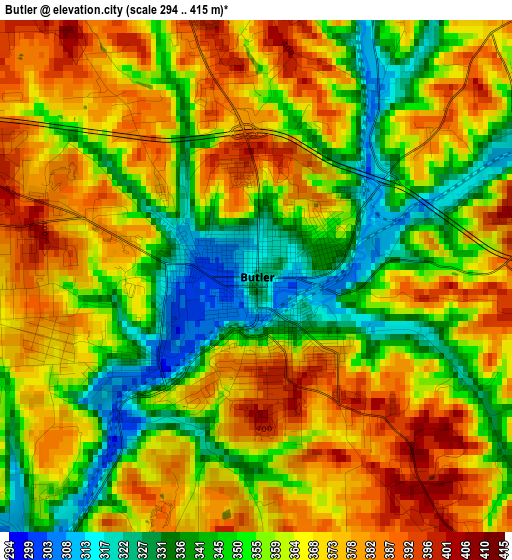
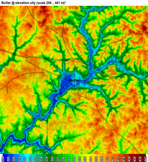
Below is the Elevation map of Butler, which displays elevation range with different colors. Scale of the first map is from 294 to 415 m (965 to 1362 ft) with average elevation of 361.4 meters (=1186 ft) [note 1]
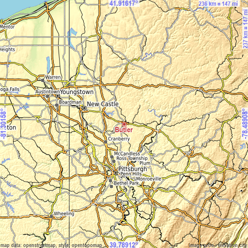
These maps also provides idea of topography and contour of this city, they are displayed at different zoom levels. More info about maps, scale and edge coordinates you can find below images.
| \ | Map #1 | Map #2 | Topo.Map |
| Scale [m] | 294..415 m | 294..441 m | × |
| Scale [ft] | 965..1362 ft | 965..1447 ft | × |
| Average | 361.4 m = 1186 ft | 374.9 m = 1230 ft | × |
| Width | 7.39 km = 4.6 mi | 14.78 km = 9.2 mi | 236.5 km = 147 mi |
| Height | 7.39 km = 4.6 mi | 14.78 km = 9.2 mi | 236.5 km = 147 mi |
| ↑Max Latitude | 40.894407° | 40.927618° | 41.91617° |
| Latitude at center | 40.86118° | 40.86118° | 40.86118° |
| ↓Min Latitude | 40.827936° | 40.794675° | 39.78912° |
| ← Min Longitude | -79.939275° | -79.983221° | -81.30158° |
| Longitude center | -79.89533° | -79.89533° | -79.89533° |
| →Max Longitude | -79.851385° | -79.807439° | -78.48908° |
Nearby cities:
Cities around Butler sort by population:
• Homeacre-Lyndora elevation 384 m
2.4 km,  299°
299°
• Shanor-Northvue 358 m
5.7 km,  342°
342°
• Meridian 390 m
5.8 km,  255°
255°
• Zelienople 290 m
21.6 km,  249°
249°
• Meadowood 404 m
2.1 km,  176°
176°
• Oak Hills 373 m
4.3 km,  200°
200°
• Evans City 285 m
17.4 km,  234°
234°
• Mars 316 m
20.8 km,  208°
208°
• Saxonburg 395 m
13.9 km,  148°
148°
• Nixon 375 m
9.1 km, 198°
• Prospect 418 m
13.6 km,  290°
290°
• Chicora 372 m
16.1 km,  52°
52°
Multilingual:
 En español:
Butler elevación 323 m.
 En France:
Butler élévation 323 m.


Sources and notes:
- [note 1] Map square and city borders are not equal. Map elevation data is calculated only from area inside that square.
- [src 1] Elevation data from geonames database provided with same terms of usage.
- [src 2] The elevation map of Butler is generated using elevation data from NASA's 3 arcsec (90m) resolution SRTM data.
- [src 3] Base (background) map © OpenStreetMap contributors tiles are generated by Geofabrik and OpenTopoMap.
Copyright & License:
This Butler Elevation Map is licensed under CC BY-SA. You may reuse any part from this page, if you give a proper credit by linking to this URL:
 More info on terms of use page.