Mount Union elevation
Mount Union (Pennsylvania, Huntingdon County), United States elevation is 188 meters and Mount Union elevation in feet is 617 ft above sea level [src 1]. Mount Union is a populated place (feature code) with elevation that is 91 meters (299 ft) smaller than average city elevation in United States.
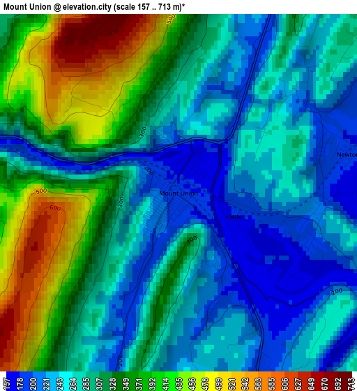
Below is the Elevation map of Mount Union, which displays elevation range with different colors. Scale of the first map is from 157 to 713 m (515 to 2339 ft) with average elevation of 304.8 meters (=1000 ft) [note 1]
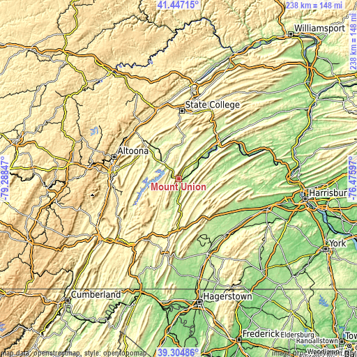
These maps also provides idea of topography and contour of this city, they are displayed at different zoom levels. More info about maps, scale and edge coordinates you can find below images.
| \ | Map #1 | Topo.Map |
| Scale [m] | 157..713 m | × |
| Scale [ft] | 515..2339 ft | × |
| Average | 304.8 m = 1000 ft | × |
| Width | 7.44 km = 4.6 mi | 238.2 km = 148 mi |
| Height | 7.44 km = 4.6 mi | 238.2 km = 148 mi |
| ↑Max Latitude | 40.417985° | 41.44715° |
| Latitude at center | 40.38452° | 40.38452° |
| ↓Min Latitude | 40.351038° | 39.30486° |
| ← Min Longitude | -77.926165° | -79.28847° |
| Longitude center | -77.88222° | -77.88222° |
| →Max Longitude | -77.838275° | -76.47597° |
Nearby cities:
Cities around Mount Union sort by population:
• Lewistown elevation 155 m
35.5 km,  47°
47°
• Huntingdon 195 m
15.5 km,  315°
315°
• Hollidaysburg 290 m
43.2 km,  276°
276°
• Burnham 169 m
38.7 km,  43°
43°
• Martinsburg 428 m
38.3 km,  257°
257°
• Belleville 242 m
27.9 km,  28°
28°
• Church Hill 239 m
40.8 km, 35°
• Pine Grove Mills 401 m
38.8 km,  359°
359°
• Highland Park 176 m
37.4 km, 45°
• Williamsburg 259 m
28.2 km,  287°
287°
• McConnellstown 216 m
18.5 km, 294°
• Yeagertown 179 m
38.4 km, 41°
Multilingual:
 En español:
Mount Union elevación 188 m.
 En France:
Mount Union élévation 188 m.
 Auf Deutsch:
Mount Union höhe über dem Meeresspiegel ist 188 m.

Sources and notes:
- [note 1] Map square and city borders are not equal. Map elevation data is calculated only from area inside that square.
- [src 1] Elevation data from geonames database provided with same terms of usage.
- [src 2] The elevation map of Mount Union is generated using elevation data from NASA's 3 arcsec (90m) resolution SRTM data.
- [src 3] Base (background) map © OpenStreetMap contributors tiles are generated by Geofabrik and OpenTopoMap.
Copyright & License:
This Mount Union Elevation Map is licensed under CC BY-SA. You may reuse any part from this page, if you give a proper credit by linking to this URL:
 More info on terms of use page.