Huntingdon elevation
Huntingdon (Pennsylvania, Huntingdon County), United States elevation is 195 meters and Huntingdon elevation in feet is 640 ft above sea level [src 1]. Huntingdon is a seat of a second-order administrative division (feature code) with elevation that is 84 meters (276 ft) smaller than average city elevation in United States.
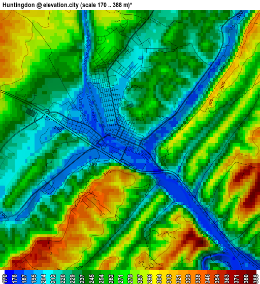
Below is the Elevation map of Huntingdon, which displays elevation range with different colors. Scale of the first map is from 170 to 388 m (558 to 1273 ft) with average elevation of 252.6 meters (=829 ft) [note 1]
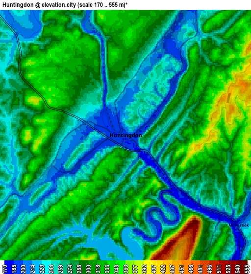
These maps also provides idea of topography and contour of this city, they are displayed at different zoom levels. More info about maps, scale and edge coordinates you can find below images.
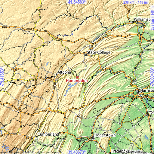
| \ | Map #1 | Map #2 | Topo.Map |
| Scale [m] | 170..388 m | 170..555 m | × |
| Scale [ft] | 558..1273 ft | 558..1821 ft | × |
| Average | 252.6 m = 829 ft | 284.6 m = 934 ft | × |
| Width | 7.43 km = 4.6 mi | 14.87 km = 9.2 mi | 237.8 km = 147.8 mi |
| Height | 7.43 km = 4.6 mi | 14.87 km = 9.2 mi | 237.8 km = 147.8 mi |
| ↑Max Latitude | 40.518216° | 40.551614° | 41.54583° |
| Latitude at center | 40.4848° | 40.4848° | 40.4848° |
| ↓Min Latitude | 40.451368° | 40.417919° | 39.40673° |
| ← Min Longitude | -78.054225° | -78.098171° | -79.41653° |
| Longitude center | -78.01028° | -78.01028° | -78.01028° |
| →Max Longitude | -77.966335° | -77.922389° | -76.60403° |
Nearby cities:
Cities around Huntingdon sort by population:
• Altoona elevation 359 m
32.7 km,  276°
276°
• Hollidaysburg 290 m
32.7 km,  258°
258°
• Tyrone 275 m
28.3 km,  316°
316°
• Greenwood 364 m
29.9 km, 280°
• Mount Union 188 m
15.5 km,  135°
135°
• Lakemont 368 m
32 km,  267°
267°
• Bellwood 323 m
29.7 km,  296°
296°
• Belleville 242 m
27.5 km,  60°
60°
• Pine Grove Mills 401 m
29.6 km,  20°
20°
• Williamsburg 259 m
16.2 km, 261°
• McConnellstown 216 m
7 km,  239°
239°
• Tipton 304 m
29.4 km, 304°
Multilingual:
 En español:
Huntingdon elevación 195 m.
 En France:
Huntingdon élévation 195 m.
 Auf Deutsch:
Huntingdon höhe über dem Meeresspiegel ist 195 m.

Sources and notes:
- [note 1] Map square and city borders are not equal. Map elevation data is calculated only from area inside that square.
- [src 1] Elevation data from geonames database provided with same terms of usage.
- [src 2] The elevation map of Huntingdon is generated using elevation data from NASA's 3 arcsec (90m) resolution SRTM data.
- [src 3] Base (background) map © OpenStreetMap contributors tiles are generated by Geofabrik and OpenTopoMap.
Copyright & License:
This Huntingdon Elevation Map is licensed under CC BY-SA. You may reuse any part from this page, if you give a proper credit by linking to this URL:
 More info on terms of use page.