McConnellstown elevation
McConnellstown (Pennsylvania, Huntingdon County), United States elevation is 216 meters and McConnellstown elevation in feet is 709 ft above sea level [src 1]. McConnellstown is a populated place (feature code) with elevation that is 63 meters (207 ft) smaller than average city elevation in United States.
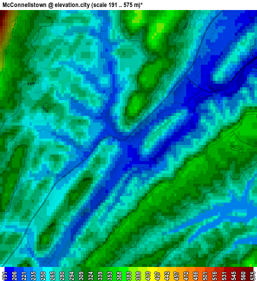
Below is the Elevation map of McConnellstown, which displays elevation range with different colors. Scale of the first map is from 191 to 575 m (627 to 1886 ft) with average elevation of 274.8 meters (=902 ft) [note 1]
These maps also provides idea of topography and contour of this city, they are displayed at different zoom levels. More info about maps, scale and edge coordinates you can find below images.
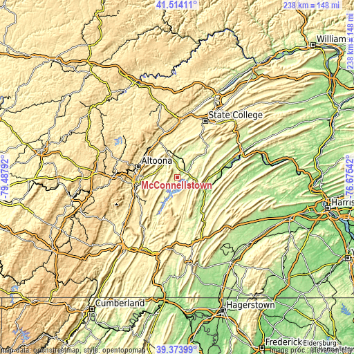
| \ | Map #1 | Topo.Map |
| Scale [m] | 191..575 m | × |
| Scale [ft] | 627..1886 ft | × |
| Average | 274.8 m = 902 ft | × |
| Width | 7.44 km = 4.6 mi | 238 km = 147.9 mi |
| Height | 7.44 km = 4.6 mi | 238 km = 147.9 mi |
| ↑Max Latitude | 40.486002° | 41.51411° |
| Latitude at center | 40.45257° | 40.45257° |
| ↓Min Latitude | 40.419122° | 39.37399° |
| ← Min Longitude | -78.125615° | -79.48792° |
| Longitude center | -78.08167° | -78.08167° |
| →Max Longitude | -78.037725° | -76.67542° |
Nearby cities:
Cities around McConnellstown sort by population:
• Altoona elevation 359 m
27.5 km,  285°
285°
• Huntingdon 195 m
7 km,  59°
59°
• Hollidaysburg 290 m
26.2 km,  263°
263°
• Tyrone 275 m
27.6 km,  331°
331°
• Roaring Spring 398 m
29.2 km,  243°
243°
• Greenwood 364 m
25.1 km, 291°
• Mount Union 188 m
18.5 km,  114°
114°
• Martinsburg 428 m
25.9 km,  232°
232°
• Lakemont 368 m
26 km,  274°
274°
• Bellwood 323 m
26.5 km,  309°
309°
• Williamsburg 259 m
10 km,  276°
276°
• Tipton 304 m
27.3 km,  318°
318°
Multilingual:
 En español:
McConnellstown elevación 216 m.
 En France:
McConnellstown élévation 216 m.
 Auf Deutsch:
McConnellstown höhe über dem Meeresspiegel ist 216 m.

Sources and notes:
- [note 1] Map square and city borders are not equal. Map elevation data is calculated only from area inside that square.
- [src 1] Elevation data from geonames database provided with same terms of usage.
- [src 2] The elevation map of McConnellstown is generated using elevation data from NASA's 3 arcsec (90m) resolution SRTM data.
- [src 3] Base (background) map © OpenStreetMap contributors tiles are generated by Geofabrik and OpenTopoMap.
Copyright & License:
This McConnellstown Elevation Map is licensed under CC BY-SA. You may reuse any part from this page, if you give a proper credit by linking to this URL:
 More info on terms of use page.