Martinsburg elevation
Martinsburg (Pennsylvania, Blair County), United States elevation is 428 meters and Martinsburg elevation in feet is 1404 ft above sea level [src 1]. Martinsburg is a populated place (feature code) with elevation that is 149 meters (489 ft) bigger than average city elevation in United States.
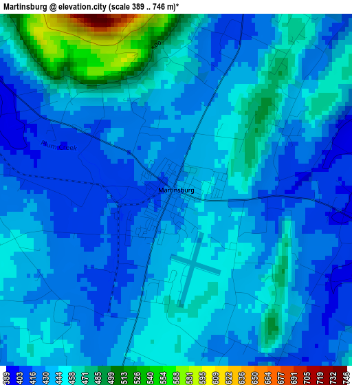
Below is the Elevation map of Martinsburg, which displays elevation range with different colors. Scale of the first map is from 389 to 746 m (1276 to 2448 ft) with average elevation of 441.4 meters (=1448 ft) [note 1]
These maps also provides idea of topography and contour of this city, they are displayed at different zoom levels. More info about maps, scale and edge coordinates you can find below images.
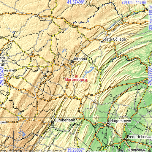
| \ | Map #1 | Topo.Map |
| Scale [m] | 389..746 m | × |
| Scale [ft] | 1276..2448 ft | × |
| Average | 441.4 m = 1448 ft | × |
| Width | 7.45 km = 4.6 mi | 238.5 km = 148.2 mi |
| Height | 7.45 km = 4.6 mi | 238.5 km = 148.2 mi |
| ↑Max Latitude | 40.344692° | 41.37498° |
| Latitude at center | 40.31119° | 40.31119° |
| ↓Min Latitude | 40.277672° | 39.23037° |
| ← Min Longitude | -78.368125° | -79.73043° |
| Longitude center | -78.32418° | -78.32418° |
| →Max Longitude | -78.280235° | -76.91793° |
Nearby cities:
Cities around Martinsburg sort by population:
• Altoona elevation 359 m
23.8 km,  345°
345°
• Hollidaysburg 290 m
14 km,  336°
336°
• Roaring Spring 398 m
6.3 km,  295°
295°
• Portage 516 m
30.7 km,  286°
286°
• Greenwood 364 m
25.1 km, 353°
• Lakemont 368 m
18.8 km, 343°
• Cresson 617 m
28 km,  306°
306°
• Claysburg 350 m
10.8 km,  261°
261°
• Gallitzin 667 m
27.1 km, 314°
• Williamsburg 259 m
19.8 km,  32°
32°
• Duncansville 312 m
15.6 km,  323°
323°
• McConnellstown 216 m
25.9 km,  52°
52°
Multilingual:
 En español:
Martinsburg elevación 428 m.
 En France:
Martinsburg élévation 428 m.
 Auf Deutsch:
Martinsburg höhe über dem Meeresspiegel ist 428 m.

Sources and notes:
- [note 1] Map square and city borders are not equal. Map elevation data is calculated only from area inside that square.
- [src 1] Elevation data from geonames database provided with same terms of usage.
- [src 2] The elevation map of Martinsburg is generated using elevation data from NASA's 3 arcsec (90m) resolution SRTM data.
- [src 3] Base (background) map © OpenStreetMap contributors tiles are generated by Geofabrik and OpenTopoMap.
Copyright & License:
This Martinsburg Elevation Map is licensed under CC BY-SA. You may reuse any part from this page, if you give a proper credit by linking to this URL:
 More info on terms of use page.